IMAGES TAKEN NEAR TO
Lovat Lane, LONDON, EC3R 8DT
Introduction
This page details the photographs taken nearby to Lovat Lane, EC3R 8DT by members of the Geograph project.
The Geograph project started in 2005 with the aim of publishing, organising and preserving representative images for every square kilometre of Great Britain, Ireland and the Isle of Man.

There are currently over 7.5m images from over14,400 individuals and you can help contribute to the project by visiting https://www.geograph.org.uk
Image Map
Images are licensed for reuse under creativecommons.org/licenses/by-sa/2.0
Notes
- Clicking on the map will re-center to the selected point.
- The higher the marker number, the further away the image location is from the centre of the postcode.
Image Listing (3881 Images Found)
Images are licensed for reuse under creativecommons.org/licenses/by-sa/2.0
Image
Details
Distance
1
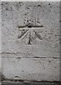
Ordnance Survey 1GL Bolt
This OS Bolt can be found on the SE angle of St Mary's Church. It marks a point 13.437m above mean sea level.
Image: © Adrian Dust
Taken: 10 Aug 2016
0.00 miles
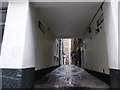
2
The City- go east old man (192)
Junction of Botolph Alley and Lovat Lane
I have my back to the entrance to St Mary's https://alondoninheritance.com/london-churches/st-mary-at-hill-and-lovat-lane/
Image: © Basher Eyre
Taken: 16 Nov 2019
0.00 miles
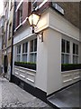
3
The City- go east old man (193)
Above a doorway in Lovat Lane
Image: © Basher Eyre
Taken: 16 Nov 2019
0.00 miles
5
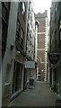
Botolph Alley, City of London
This alleyway takes its name from the now-vanished church of St Botolph Billingsgate. At its end can be seen the church of St Mary at Hill.
Image: © Christopher Hilton
Taken: 13 Jun 2016
0.01 miles
6
The City- go east old man (194)
Botolph Alley- in mediaeval times this was in the parish of St Botolph Billingsgate https://en.wikipedia.org/wiki/St_Botolph_Billingsgate
Image: © Basher Eyre
Taken: 16 Nov 2019
0.01 miles
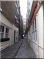
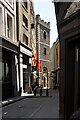
7
Lovat Lane
Lovat Lane leads from Eastcheap to the Wren church St Mary at Hill, see http://www.webcitation.org/6Dpy8ZAKs .
Image: © Roger Jones
Taken: 16 Jan 2013
0.01 miles
8
View down Pudding Lane from Eastcheap
Pudding Lane was the location of Thomas Fareiner's bakery where the Great Fire of London began in 1666. It is around 62m from the nearby Monument. How do I know this? The height of the Monument (62m) equals the distance from it to the site of the bakers' shop! Looking south-southwest.
Image: © Robert Lamb
Taken: 12 Apr 2014
0.01 miles
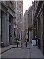
9
A-spiring to find a hundred churches (22)
Such was the proximity of parishes in the City of London, that until 1903 I could have walked maybe 50 yards from St George Botolph Lane, then through this alley at the end of which I can see St Mary-at-Hill https://en.wikipedia.org/wiki/St_Mary-at-Hill
Image: © Basher Eyre
Taken: 20 Nov 2016
0.01 miles
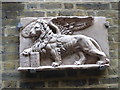
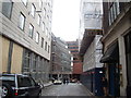
10
City of London : Lovat Lane
In the background the tower of the Grade I listed Wren church of St Mary-at-Hill.
Image: © Jim Osley
Taken: 8 Jun 2021
0.01 miles