IMAGES TAKEN NEAR TO
Bow Locks, Gillender Street, LONDON, E3 3JY
Introduction
This page details the photographs taken nearby to Bow Locks, Gillender Street, E3 3JY by members of the Geograph project.
The Geograph project started in 2005 with the aim of publishing, organising and preserving representative images for every square kilometre of Great Britain, Ireland and the Isle of Man.

There are currently over 7.5m images from over14,400 individuals and you can help contribute to the project by visiting https://www.geograph.org.uk
Image Map (Loading...)


Getting Data...Please wait
Leaflet Map data © OpenStreetMap
Images are licensed for reuse under creativecommons.org/licenses/by-sa/2.0
Notes
- Clicking on the map will re-center to the selected point.
- The higher the marker number, the further away the image location is from the centre of the postcode.
Image Listing (165 Images Found)
Images are licensed for reuse under creativecommons.org/licenses/by-sa/2.0
Image
Details
Distance
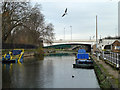
2
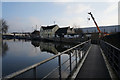
Bow Lock
Bow Lock on the River Lea. Taken from the back of the old British Waterways lock office.
Image: © Julie Cookson
Taken: 3 Nov 2007
0.02 miles
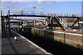
3
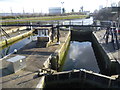
Bow Locks
These locks see little use nowadays as compared with past years. They can only be used near high tide, as if the tide is too low, Bow Creek (seen beyond the locks) would not be navigable. The locks are useful only for (a) craft using Bow Creek to and from the Thames and requiring access to the Lee Navigation, or (b) craft to or from Limehouse Cut wishing to access Abbey Creek, (unlikely!). There is now no access this way to Bow Back Rivers, as Three Mills Sluice is not now navigable.
If the high tide is just right, the gates at both ends can be opened allowing craft to pass freely through without stopping!
Image: © Dr Neil Clifton
Taken: 3 Sep 2008
0.02 miles
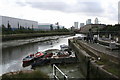
4
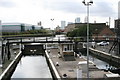
Bow Tidal Locks and Bow Creek
Bow Tidal Locks link the tidal River Lea (Bow Creek) with the Limehouse Cut and non-tidal River Lea. These are the lowest locks on the whole River Lea system.
This view is from the bridge which carries the towpath across the locks. Bow Creek and the River Lea are beyond the lock gates, while the locks lead up to the Limehouse Cut which is behind.
Image: © Marathon
Taken: 26 Feb 2014
0.02 miles
5
Limehouse Cut
The north end, where it joins the main River Lee Navigation.
Image: © Robin Webster
Taken: 11 Dec 2010
0.02 miles
6
Bow Creek near Bow Locks
This shows the head of the Creek at low tide and it is easy to see why it is not navigable at that time. The Creek writhes like a demented serpent, and it is long way by water to the Thames. Excellent views of the Creek can be had from the Docklands Light Railway between Blackwall and Canning Town, but very few boats use it now. However, it is said that certain heavy parts required for the 2012 London Olympics are being brought in by water this way: apparently they are too large for Limehouse Cut.
Image: © Dr Neil Clifton
Taken: 3 Sep 2008
0.03 miles
7
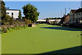
Limehouse Cut approaching the River Lea
A thin green layer of weed coats the entire surface of the canal giving the appearance of a well manicured lawn
Image: © Chris Heaton
Taken: 1 Sep 2017
0.03 miles
8
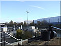
Floating towpath, Bromley-by-Bow
The eastern end of a very long section of floating towpath, built to bridge a long gap in the regular towpath of the Limehouse Cut where it passes under the Blackwall Tunnel Northern Approach and Gillender Street.
Image: © Robin Webster
Taken: 11 Dec 2010
0.03 miles
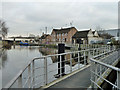
10
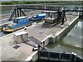
Bow Locks
Connecting the Limehouse Cut (this end) to the tidal River Lea (far end).
Image: © David Martin
Taken: 6 Aug 2013
0.03 miles