IMAGES TAKEN NEAR TO
Asher Way, LONDON, E1W 2JY
Introduction
This page details the photographs taken nearby to Asher Way, E1W 2JY by members of the Geograph project.
The Geograph project started in 2005 with the aim of publishing, organising and preserving representative images for every square kilometre of Great Britain, Ireland and the Isle of Man.

There are currently over 7.5m images from over14,400 individuals and you can help contribute to the project by visiting https://www.geograph.org.uk
Image Map
Images are licensed for reuse under creativecommons.org/licenses/by-sa/2.0
Notes
- Clicking on the map will re-center to the selected point.
- The higher the marker number, the further away the image location is from the centre of the postcode.
Image Listing (279 Images Found)
Images are licensed for reuse under creativecommons.org/licenses/by-sa/2.0
Image
Details
Distance
1
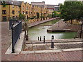
Canals of Wapping
It is hard to imagine that just over 30 years ago, this area was one huge inland dock. The London Dock at Wapping was completed in 1805 to serve the growing trade coming into London. By the 1960s the docks were almost derelict so the London Docklands Development Corporation drained the area and built a huge estate of mixed housing. The canals that remain are a link with the past but this is now a quiet residential area where once it was the heart of dockland.
Image: © David Williams
Taken: 12 Aug 2006
0.02 miles
2
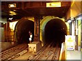
Brunel's Tunnel - north entrance
Arches in Wapping underground station as originally constructed in 1842. The south arches cannot be seen from the platform of Rotherhithe underground station.
Image: © Chris Lordan
Taken: 5 Aug 2007
0.02 miles
3

No ships - just houses!
The old London Docks at Wapping were built in London in 1805. Twenty-five years later they were out of date as larger ships were unable to negotiate the entrance from the River Thames. Yet it wasn't until the 1960s that the docks were finally closed. Along came the London Docklands Development Corporation and drained the docks to create a new housing estate. Today, it is difficult to imagine that this was an 18th century dock; homes now overlook narrow canals which have replaced the wider expanse of water.
Image: © David Williams
Taken: 12 Aug 2006
0.03 miles
4

Footbridge over Tobacco Dock Canal
A canal leades from the Thames to Tobacco Dock (in the background) in East London. As its name suggests, Tobacco Dock was where tobacco imported from overseas was unloaded from ships then stored.
The whole area was once occupied by the London Docks, but is now largely used for housing. The canalpath is now used by National Cycle Network Route 13.
The bridge links between Kennet Street and Waterman Way.
Image: © David Anstiss
Taken: 23 May 2012
0.06 miles
5

Turf Zone "WappingCanal"
The Ornamental Canal, Wapping, London.
Image: © Ian S
Taken: 26 Dec 2022
0.07 miles
6

Tobacco Dock Canal
This canal leades from Tobacco Dock towards the River Thames. As its name suggests, Tobacco Dock was where tobacco imported from overseas was unloaded from ships then stored.
The whole area was once occupied by the London Docks, but is now largely used for housing.
In the background is the Shard Tower (at London Bridge).
Image: © David Anstiss
Taken: 23 May 2012
0.07 miles

8
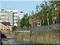
Spirit Quay, Wapping
The Wapping area, on the north bank of the River Thames, was once home to the London Docks. Some reminders of the docks remain, such as Spirit Quay. The quay is now flanked by modern housing while in the background, the top of one of the Canary Wharf towers is visible.
Image: © Malc McDonald
Taken: 3 Jun 2011
0.08 miles
9

Canal near Tobacco Dock, Wapping
A canal leading to Tobacco Dock in East London. As its name suggests, Tobacco Dock was where tobacco imported from overseas was unloaded from ships then stored.
The whole area was once occupied by the London Docks, but is now largely used for housing.
Image: © Malc McDonald
Taken: 3 Jun 2011
0.08 miles
10

Tobacco Dock Canal (2)
A canal leading left to Tobacco Dock from the River Thames. Another short spur heads straight on.
As its name suggests, Tobacco Dock was where tobacco imported from overseas was unloaded from ships then stored.
The whole area was once occupied by the London Docks, but is now largely used for housing.
Image: © David Anstiss
Taken: 23 May 2012
0.08 miles