IMAGES TAKEN NEAR TO
Pan Peninsula Square, LONDON, E14 9HG
Introduction
This page details the photographs taken nearby to Pan Peninsula Square, E14 9HG by members of the Geograph project.
The Geograph project started in 2005 with the aim of publishing, organising and preserving representative images for every square kilometre of Great Britain, Ireland and the Isle of Man.

There are currently over 7.5m images from over14,400 individuals and you can help contribute to the project by visiting https://www.geograph.org.uk
Image Map
Images are licensed for reuse under creativecommons.org/licenses/by-sa/2.0
Notes
- Clicking on the map will re-center to the selected point.
- The higher the marker number, the further away the image location is from the centre of the postcode.
Image Listing (543 Images Found)
Images are licensed for reuse under creativecommons.org/licenses/by-sa/2.0
Image
Details
Distance
2
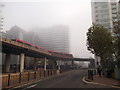
London Docklands Development, 1991: Canary Wharf Tower seen from Marsh Wall near South Quay DLR station
View NW across the Island Gardens line, South Quay station being just off to the right.
Image: © Ben Brooksbank
Taken: 25 Aug 1991
0.02 miles
3
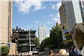
View of the Pan Peninsula apartment block on Millharbour from Marsh Wall #2
Looking south-southeast.
Image: © Robert Lamb
Taken: 13 Aug 2017
0.02 miles
4
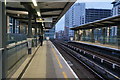
Docklands Light Railway
The DLR west of South Quay station.
Image: © Peter McDermott
Taken: 4 Nov 2024
0.02 miles
5

View of Clipper House on the corner of Byng Street and Mastmaker Road from Marsh Wall
Looking south-southwest.
Image: © Robert Lamb
Taken: 31 Jul 2016
0.02 miles
6
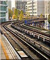
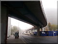
DLR bridge over Marsh Wall, South Quay (2)
The concrete bridge carries an overhead light transit railway from Heron Quay Station towards South Quay Station.
Around are various large office blocks.
Image: © David Anstiss
Taken: 20 Nov 2011
0.02 miles
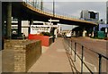
7
DLR bridge over Marsh Wall, South Quay
The concrete bridge carries an overhead light transit railway from South Quay Station towards Heron Quay.
Image: © David Anstiss
Taken: 20 Nov 2011
0.02 miles
8

View along the underside of the DLR viaduct on Marsh Wall
Looking north-northwest.
Image: © Robert Lamb
Taken: 31 Jul 2016
0.02 miles
9
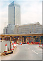
Marsh Wall, July 1989 (1)
View eastwards at the junction with Millharbour. A sign points the way to the offices of the London Docklands Development Corporation - a pretty hectic place at the time. The Telegraph group were early adopters, and early arrivals 'on the island'.
The photo was taken on a Sunday afternoon - but I have to say that even on weekdays there was the sense that the transformation of the area had just begun.
South Quay DLR station is just behind the camera, to the left.
Image: © Stefan Czapski
Taken: 16 Jul 1989
0.02 miles
10
View of the Pan Peninsula apartment block on Millharbour from Marsh Wall
Looking south-southeast.
Image: © Robert Lamb
Taken: 13 Aug 2017
0.02 miles