IMAGES TAKEN NEAR TO
East Ferry Road, LONDON, E14 3BT
Introduction
This page details the photographs taken nearby to East Ferry Road, E14 3BT by members of the Geograph project.
The Geograph project started in 2005 with the aim of publishing, organising and preserving representative images for every square kilometre of Great Britain, Ireland and the Isle of Man.

There are currently over 7.5m images from over14,400 individuals and you can help contribute to the project by visiting https://www.geograph.org.uk
Image Map (Loading...)


Getting Data...Please wait
Leaflet Map data © OpenStreetMap
Images are licensed for reuse under creativecommons.org/licenses/by-sa/2.0
Notes
- Clicking on the map will re-center to the selected point.
- The higher the marker number, the further away the image location is from the centre of the postcode.
Image Listing (272 Images Found)
Images are licensed for reuse under creativecommons.org/licenses/by-sa/2.0
Image
Details
Distance
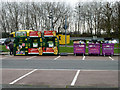
1
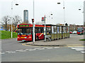
D6 bus at Crossharbour ASDA
This is at the southern end of the route.
Image: © Robin Webster
Taken: 5 Mar 2011
0.02 miles
2
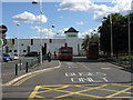
Asda Superstore Bus Stops - Crossharbour
Image: © Peter Whatley
Taken: 26 May 2009
0.02 miles
3
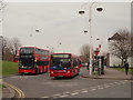
Bus Terminus, East Ferry Road, Cubitt Town, E14
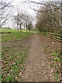
A small terminus in the shadow of an ASDA hypermarket, near Crossharbour DLR (Docklands Light Railway) station. There is pedestrian access into the Mudchute City Farm and Park in the corner of this supermarket's car park ahead. Apparently the township is named after William Cubitt, a Lord Mayor of London in the 1860s. His brothers Thomas and Lewis were architects and engineers who built much of C19th London, including King's Cross station.
Image: © David Hallam-Jones
Taken: 2 Apr 2016
0.03 miles
4
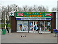
Britannia Pharmacy, Crossharbour ASDA
Tacked on to a hypermarket here.
Image: © Robin Webster
Taken: 5 Mar 2011
0.06 miles
5
TurfZone "DogHealth"
Island Health Centre, Isle of Dogs, London.
Image: © Ian S
Taken: 25 Dec 2022
0.06 miles
7
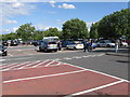
Asda Superstore Car Park - Crossharbour
Image: © Peter Whatley
Taken: 26 May 2009
0.07 miles
8
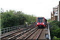
Approaching Crossharbour station
A northbound Docklands Light Railway train approaching Crossharbour
Image: © Dr Neil Clifton
Taken: 14 Jun 2012
0.08 miles
9
Recycling bins, E14
In the Asda car park.
Image: © Robin Webster
Taken: 5 Mar 2011
0.08 miles
10
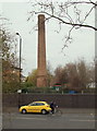
East Ferry Road, Cupitt Town, London, E14
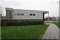
Immediately behind the photographer is an access point to/from the Mudchute City Farm and Urban Park site. The base of this preserved redundant chimney is situated at the side of a service road on the edge of a new-build residential development on Undine Road, on the other side of this wall. 100 metres or so behind the chimney lies the Outer Millwall Dock. The fir tree given annually to the people of London by the city of Oslo as a token of gratitude for help received during WWII was, in the past, shipped to Millwall Docks. Its transportation was conducted free of charge by the Fred Olsen Line, a company with strong links to the Isle of Dogs. For example, Canary Wharf was named at this company’s request in the 1930s, and still later, they operated a cruise liner terminal in Millwall Docks.
Image: © David Hallam-Jones
Taken: 2 Apr 2016
0.08 miles