IMAGES TAKEN NEAR TO
Staffa Road, LONDON, E10 7PY
Introduction
This page details the photographs taken nearby to Staffa Road, E10 7PY by members of the Geograph project.
The Geograph project started in 2005 with the aim of publishing, organising and preserving representative images for every square kilometre of Great Britain, Ireland and the Isle of Man.

There are currently over 7.5m images from over14,400 individuals and you can help contribute to the project by visiting https://www.geograph.org.uk
Image Map (Loading...)


Getting Data...Please wait
Leaflet Map data © OpenStreetMap
Images are licensed for reuse under creativecommons.org/licenses/by-sa/2.0
Notes
- Clicking on the map will re-center to the selected point.
- The higher the marker number, the further away the image location is from the centre of the postcode.
Image Listing (26 Images Found)
Images are licensed for reuse under creativecommons.org/licenses/by-sa/2.0
Image
Details
Distance
1
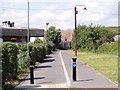
Foot/cycle path from Argall Way
Leading to Waltham Road and eventually to South Access Road and Lowhall Sports ground.
Image: © Richard Dunn
Taken: 25 Jul 2009
0.06 miles
2
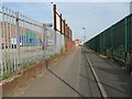
Walthamstow: Black Path
Black Path is a pedestrian / cycle way that runs through the Argall Avenue Industrial Estate, bounding the Allied Bakeries site on the left.
Image: © Nigel Cox
Taken: 25 Aug 2016
0.14 miles
3
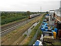
Lee Valley Railway Line
Old large scale Ordnance Survey maps available online give some indication of the pre-nationalisation history of this railway, as follows:-
1851: Eastern Counties Railway (Cambridge Line)
1865: Great Eastern Railway (Cambridge Line)
1895 & 1915: Great Eastern Railway (Cambridge Old Main Line)
1936: London & North Eastern Railway (Stratford & Tottenham Line)
1946: London & North Eastern Railway (Cambridge Old Main Line)
Just visible in the grass to the right is another set of tracks, now abandoned, that was once part of the long-dismantled Lea Bridge Curve that linked the 1895 railway here with the Great Eastern Railway's Walthamstow & Chingford Branch Line. Where the flooded track is now was the second line of this curve.
The train in sight has just left Lea Bridge Station and is heading northbound to Tottenham Hale Station.
This is the view from the Argall Way footbridge.
Image: © Nigel Cox
Taken: 25 Aug 2016
0.14 miles
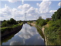
4
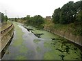
River Lee Flood Relief Channel
Construction work on the channel commenced in 1947 after serious flooding in the Lee Valley. Here it is a concrete conduit maybe about 17 or 18 metres wide. This is the view from the bridge that carries the public footpath linking Argall Way with Leyton and Walthamstow Marshes over the channel.
Image: © Nigel Cox
Taken: 25 Aug 2016
0.16 miles
5
River Lea Flood Channel
Built in 1950s to eleviate the problem of flooding of the River Lea.
Image: © Richard Dunn
Taken: 25 Jul 2009
0.16 miles
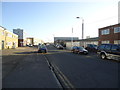
6
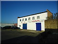
Cash and carry warehouse, Rigg Approach, London E10
Image: © Stacey Harris
Taken: 14 Jan 2012
0.17 miles
7
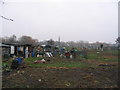
Allotments near Lea Bridge Road
These allotments are adjacent to a bleak industrial estate : a neglected and overlooked enclave of East London.
Image: © Andrew Dann
Taken: 8 Jan 2006
0.18 miles
8
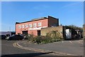
Berva Plastico on Rigg Approach, Leyton
Image: © David Howard
Taken: 23 Mar 2020
0.18 miles
10
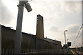
View of a factory chimney from the new Lea Bridge railway station
Lea Bridge station opened just three weeks ago, marking 31 years since the original station was demolished in 1985. Looking south-southwest.
Image: © Robert Lamb
Taken: 28 May 2016
0.19 miles