IMAGES TAKEN NEAR TO
Ham Lane, STOURBRIDGE, DY9 0UD
Introduction
This page details the photographs taken nearby to Ham Lane, DY9 0UD by members of the Geograph project.
The Geograph project started in 2005 with the aim of publishing, organising and preserving representative images for every square kilometre of Great Britain, Ireland and the Isle of Man.

There are currently over 7.5m images from over14,400 individuals and you can help contribute to the project by visiting https://www.geograph.org.uk
Image Map
Images are licensed for reuse under creativecommons.org/licenses/by-sa/2.0
Notes
- Clicking on the map will re-center to the selected point.
- The higher the marker number, the further away the image location is from the centre of the postcode.
Image Listing (21 Images Found)
Images are licensed for reuse under creativecommons.org/licenses/by-sa/2.0
Image
Details
Distance
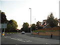
3

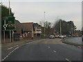
A491, Hagley Road, Ham Lane Island, Pedmore
Image: © Roy Hughes
Taken: 19 Apr 2014
0.14 miles
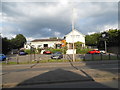
4
Approach to Pedmore
The view down Pedmore Lane towards the A491 Island.
Image: © Gordon Griffiths
Taken: 20 Aug 2011
0.15 miles
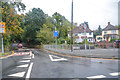
6
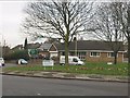
Hagley Road (A491), Pedmore
The building on the left is a local school.
Image: © Peter Whatley
Taken: 17 Jan 2012
0.19 miles
7
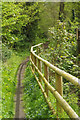
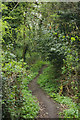
Footpath to Wollescote
The public footpath sign (out of shot) indicates that this leads to Wollescote (one mile). Most people probably prefer to use it for a pleasant stroll through Ham Dingle.
Image: © Stephen McKay
Taken: 25 Apr 2018
0.20 miles
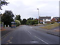
8
Stourbridge : Old Ham Lane
Looking along Old Ham Lane in Stourbridge.
Image: © Lewis Clarke
Taken: 29 Sep 2019
0.22 miles
9
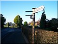
Old Road Sign
This old Sign is found at the junction of Pedmore Lane & Gauden Road. Where it shows the directions to Pedmore (Straight On) and Wollescote. The Sign direction that is missing is thought have shown the way to Lutley up Pedmore Lane. To the left of the picture is Pedmore Hall Farm and the junction to Swindell Road can be seen on the left
Image: © Dan Quinn
Taken: 4 Nov 2006
0.22 miles
10
Ham Dingle
This path leads off Compton Road through Ham Dingle eventually emerging on Ham Lane.
Image: © Stephen McKay
Taken: 25 Apr 2018
0.22 miles