IMAGES TAKEN NEAR TO
Stourbridge Road, STOURBRIDGE, DY9 0QS
Introduction
This page details the photographs taken nearby to Stourbridge Road, DY9 0QS by members of the Geograph project.
The Geograph project started in 2005 with the aim of publishing, organising and preserving representative images for every square kilometre of Great Britain, Ireland and the Isle of Man.

There are currently over 7.5m images from over14,400 individuals and you can help contribute to the project by visiting https://www.geograph.org.uk
Image Map (Loading...)


Getting Data...Please wait
Leaflet Map data © OpenStreetMap
Images are licensed for reuse under creativecommons.org/licenses/by-sa/2.0
Notes
- Clicking on the map will re-center to the selected point.
- The higher the marker number, the further away the image location is from the centre of the postcode.
Image Listing (31 Images Found)
Images are licensed for reuse under creativecommons.org/licenses/by-sa/2.0
Image
Details
Distance
2
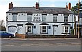
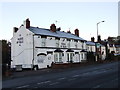
Prince of Wales (2), 65 Stourbridge Road, Hagley, Worcs
The pub survived as a going concern for around 190 years but now closed it is fated, like so many others, to be demolished and replaced by housing. See:- Image
Image
Image: © P L Chadwick
Taken: 27 Dec 2013
0.05 miles
3
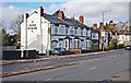
Prince of Wales (1), 65 Stourbridge Road, Hagley, Worcs
Sadly this public house served its last pint of beer some years ago, having opened in 1820. The property had been acquired by the Highways Agency for road widening but later they decided not to proceed with the scheme. Now the local council have approved a scheme, subject to certain conditions, allowing the pub to be demolished along with some neighbouring houses. In their place twelve detached houses and garages will be built.
Image
Image
Image: © P L Chadwick
Taken: 27 Dec 2013
0.05 miles
4
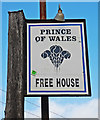
Prince of Wales (3) - sign, 65 Stourbridge Road, Hagley, Worcs
The sign for this former public house, which has been closed for several years, still remains outside the building attached to the top of a post.
The Prince of Wales is quite a popular pub name and typically, as here, the sign shows the three feathers found on the badge of the Prince of Wales.
Image
Image
Image: © P L Chadwick
Taken: 27 Dec 2013
0.06 miles
6
Public footpath from Stourbridge Road to Monument Lane, Hagley, Worcs
Near the start at Stourbridge Road. See also:- Image
Image: © P L Chadwick
Taken: 27 Dec 2013
0.07 miles
7
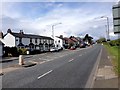
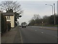
Hagley : Hagley Road A491
Looking along Hagley Road.
Image: © Lewis Clarke
Taken: 29 Sep 2019
0.07 miles
8
View north from the Prince of Wales pub
The pub itself remains closed and increasingly derelict, as shown here: http://www.geograph.org.uk/photo/2125993
Image: © Peter Whatley
Taken: 17 Jan 2012
0.08 miles
9
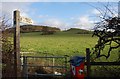
Start of public footpath from Stourbridge Road, Hagley, Worcs
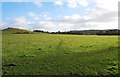
The footpath starts here at the kissing gate, and goes to the right out of this view and connects Stourbridge Road with Monument Lane. In the distance is Wychbury Hill, on which there is an iron age fort known as Wychbury Hill Camp. The obelisk, known locally as Wychbury Monument, was built by Sir Richard Lyttelton in 1747. It was recently renovated.
Image
Image: © P L Chadwick
Taken: 27 Dec 2013
0.08 miles
10
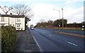
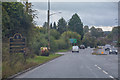
Stourbridge Road (A491), Hagley, Worcs
Shortly after passing the houses on the left, the A491 leaves the village of Hagley and the County of Worcestershire and enters Pedmore. This is an area of the town of Stourbridge, which is in Dudley Metropolitan Borough Council, in the West Midlands.
Image: © P L Chadwick
Taken: 27 Dec 2013
0.09 miles