IMAGES TAKEN NEAR TO
Winds Point, STOURBRIDGE, DY9 0PN
Introduction
This page details the photographs taken nearby to Winds Point, DY9 0PN by members of the Geograph project.
The Geograph project started in 2005 with the aim of publishing, organising and preserving representative images for every square kilometre of Great Britain, Ireland and the Isle of Man.

There are currently over 7.5m images from over14,400 individuals and you can help contribute to the project by visiting https://www.geograph.org.uk
Image Map
Images are licensed for reuse under creativecommons.org/licenses/by-sa/2.0
Notes
- Clicking on the map will re-center to the selected point.
- The higher the marker number, the further away the image location is from the centre of the postcode.
Image Listing (26 Images Found)
Images are licensed for reuse under creativecommons.org/licenses/by-sa/2.0
Image
Details
Distance
1
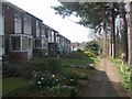
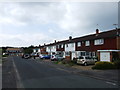
Housing alongside the Monarch's Way
The long distance footpath and North Worcestershire Way use roads and pavements through the housing estate.
Image: © John M
Taken: 21 Mar 2009
0.03 miles
5

Railway bridge on the Monarch's Way
The long distance footpath follows King Charles II's flight after the Battle of Worcester in 1651. The kings party passed through Stourbridge during the night of 3rd September in company with Colonel Gifford later finding refuge at Whiteladies Priory.
Using Public Rights Of Way, roads and canal towpaths the footpath links the known places where the king stayed during his six week journey before his escape into exile in France. There were of course no canals or railways at that time.
Image: © John M
Taken: 21 Mar 2009
0.08 miles
6
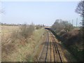
Worcester to Birmingham Railway
The former GWR line.
Image: © John M
Taken: 21 Mar 2009
0.11 miles
10
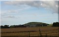
The Last Harvest
This was the last harvest in this field on Trehernes Farm, Worcester Lane, Pedmore, Stourbridge. The field is to be changed into playing fields for Old Swinford School. The local Hagley Parish Council objected to the planning application as an unacceptable development on the Green Belt.
Image: © David Pitt
Taken: 10 Aug 2007
0.14 miles