IMAGES TAKEN NEAR TO
Briarway, STOURPORT-ON-SEVERN, DY13 8ST
Introduction
This page details the photographs taken nearby to Briarway, DY13 8ST by members of the Geograph project.
The Geograph project started in 2005 with the aim of publishing, organising and preserving representative images for every square kilometre of Great Britain, Ireland and the Isle of Man.

There are currently over 7.5m images from over14,400 individuals and you can help contribute to the project by visiting https://www.geograph.org.uk
Image Map
Images are licensed for reuse under creativecommons.org/licenses/by-sa/2.0
Notes
- Clicking on the map will re-center to the selected point.
- The higher the marker number, the further away the image location is from the centre of the postcode.
Image Listing (72 Images Found)
Images are licensed for reuse under creativecommons.org/licenses/by-sa/2.0
Image
Details
Distance
1
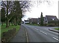
Lower Lickhill Road
On the left is Stourport War Memorial Park. On the right is the start of Stagborough Way, which is the main road through the Lickhill Estate, a post-war housing development. Lower Lickhill Road shortly becomes Lickhill Road.
Image: © P L Chadwick
Taken: 31 Dec 2009
0.11 miles
2
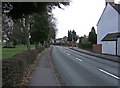
Lickhill Road
On the left is Stourport War Memorial Park, which is a public park. In the far distance, just past the lamppost on the right, is a wall-mounted George V postbox. It can be seen in more detail here:- Image Since these photographs were taken the postbox has been taken out of service and painted black.
Image: © P L Chadwick
Taken: 31 Dec 2009
0.13 miles
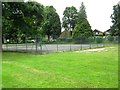
3
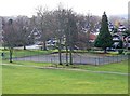
Stourport War Memorial Park - tennis courts
These are or were tennis courts, but the Town Council might convert them to a multi-use ball games area when funds permit. Update January 2019: The tennis courts have gone. Work began in late 2017 to install play equipment on part of the site where the courts were. The rest of the site has been grassed over.
Image: © P L Chadwick
Taken: 31 Dec 2009
0.14 miles
4
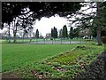
Stourport War Memorial Park - tennis courts
Photographed from Lower Lickhill Road. Another view:- Image
Update January 2019: The tennis courts have gone. Work began in late 2017 to install play equipment on part of the site where the courts were. The rest of the site has been grassed over.
Image: © P L Chadwick
Taken: 31 Dec 2009
0.14 miles
5
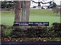
No need to be confused
This helps you to know whether you are in Lower Lickhill Road, or Lickhill Road. Not that the local authorities are always sure themselves:- Image
Image: © P L Chadwick
Taken: 31 Dec 2009
0.14 miles
8
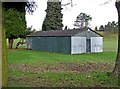
Stourport War Memorial Park - The Old Cricket Pavilion
It looks like a shed from the outside, but many years ago this was a cricket pavilion. It is of wood and corrugated steel construction. For the last 35 years or more it has been used as a scout hut. Now approval has been given for its replacement, by a new building, on the same site, for the local Scouts.
Update March 2015:- Some time ago this hut was demolished and a new hut built of brick has replaced it. See:- Image
Image: © P L Chadwick
Taken: 31 Dec 2009
0.14 miles
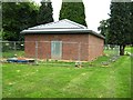
9
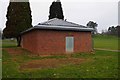
The new scout hut (1), War Memorial Park, Stourport-on-Severn
The old cricket pavilion which served as a scout hut for many years has been demolished. In its place is this brick-built hut. Probably wisely there are no windows.
Image
The old hut:- Image
Image: © P L Chadwick
Taken: 11 Mar 2015
0.15 miles
10

Floods in Stourport on Severn 2020
The park and car parks were quickly submerged by the Severn
Image: © DAVID BIRD
Taken: 27 Feb 2020
0.15 miles