IMAGES TAKEN NEAR TO
Berkeley Crescent, STOURPORT-ON-SEVERN, DY13 0HJ
Introduction
This page details the photographs taken nearby to Berkeley Crescent, DY13 0HJ by members of the Geograph project.
The Geograph project started in 2005 with the aim of publishing, organising and preserving representative images for every square kilometre of Great Britain, Ireland and the Isle of Man.

There are currently over 7.5m images from over14,400 individuals and you can help contribute to the project by visiting https://www.geograph.org.uk
Image Map
Images are licensed for reuse under creativecommons.org/licenses/by-sa/2.0
Notes
- Clicking on the map will re-center to the selected point.
- The higher the marker number, the further away the image location is from the centre of the postcode.
Image Listing (24 Images Found)
Images are licensed for reuse under creativecommons.org/licenses/by-sa/2.0
Image
Details
Distance
1
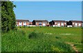
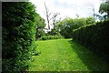
Looking from The Snipes towards Windsor Drive, Areley Kings, Worcs
The houses in the distance are on Windsor Drive, which is the edge of the built-up area.
Image: © P L Chadwick
Taken: 30 May 2021
0.16 miles
2
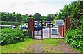
Entrance to Redstone Caravan Park, Stourport-on-Severn
One of the minor entrances to this large caravan park, from the public footpath alongside the River Severn.
Image: © P L Chadwick
Taken: 10 Jun 2012
0.16 miles
3
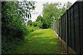
Public footpath near River Severn, Stourport-on-Severn
The path here runs between the boundary of the Redstone Caravan Park, on the left, and the fence on the right. The river is not far away.
Image: © P L Chadwick
Taken: 10 Jun 2012
0.16 miles
4
Public footpath adjacent to River Severn, Stourport-on-Severn
The footpath on this bank of the river is not very busy. The river is hidden behind the trees and the vegetation on the right. On the left, behind the bushes, is the boundary of Redstone Caravan Park.
Image: © P L Chadwick
Taken: 10 Jun 2012
0.17 miles
5
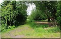
Public footpath near River Severn, Stourport-on-Severn
The footpath here runs between the two hedges, to avoid some very large static caravans, and then turns right, by the private fishing notice on the tree, to be near the river again.
Image: © P L Chadwick
Taken: 10 Jun 2012
0.17 miles
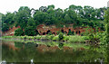
6
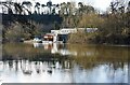
Homes and moorings by the River Severn, near Areley Kings, Worcs
These homes are high above the river to allow for flooding. The River Severn can rise quite considerably after days of heavy rainfall.
Image: © P L Chadwick
Taken: 10 Feb 2021
0.18 miles
7
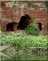
Caves in a sandstone cliff near Stourport, Worcestershire
This cliff of Triassic Wildmoor Sandstone is on the western bank of the River Severn. The area has the unsurprising name of Redstone Rock. The site was used as a hermitage as far back as the 12th century, and was said to house up to 500 men, who may have also manned the ferry crossing, which was there due to the presence of a ford until the river was dredged. (Information from the Geodiversity Partnership http://www.geowestmidlands.org.uk/wiki/index.php5?title=Sites_to_Visit/Worcestershire )
Image: © Roger D Kidd
Taken: 21 Jun 2013
0.19 miles
8
Caves in a sandstone cliff near Stourport, Worcestershire
This cliff of Triassic Wildmoor Sandstone is on the western bank of the River Severn. The area has the unsurprising name of Redstone Rock. The site was used as a hermitage as far back as the 12th century, and was said to house up to 500 men, who may have also manned the ferry crossing, which was there due to the presence of a ford until the river was dredged. (Information from the Geodiversity Partnership http://www.geowestmidlands.org.uk/wiki/index.php5?title=Sites_to_Visit/Worcestershire )
Image: © Roger D Kidd
Taken: 21 Jun 2013
0.19 miles
9
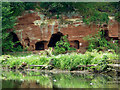
Caves by the River Severn near Stourport, Worcestershire
This cliff of Triassic Wildmoor Sandstone is on the western bank of the River Severn. The area has the unsurprising name of Redstone Rock. The site was used as a hermitage as far back as the 12th century, and was said to house up to 500 men, who may have also manned the ferry crossing, which was there due to the presence of a ford until the river was dredged. (Information from the Geodiversity Partnership http://www.geowestmidlands.org.uk/wiki/index.php5?title=Sites_to_Visit/Worcestershire )
Image: © Roger D Kidd
Taken: 21 Jun 2013
0.19 miles
10
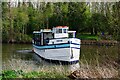
"River King" turning on River Severn, near Stourport-on-Severn, Worcs
The 90 year old trip boat, based at Stourport-on-Severn, is seen here turning around in the river to return to Stourport. Later it picked up passengers there for a trip.
Image: © P L Chadwick
Taken: 10 Apr 2021
0.20 miles