IMAGES TAKEN NEAR TO
High Terrace, BEWDLEY, DY12 1XF
Introduction
This page details the photographs taken nearby to High Terrace, DY12 1XF by members of the Geograph project.
The Geograph project started in 2005 with the aim of publishing, organising and preserving representative images for every square kilometre of Great Britain, Ireland and the Isle of Man.

There are currently over 7.5m images from over14,400 individuals and you can help contribute to the project by visiting https://www.geograph.org.uk
Image Map
Images are licensed for reuse under creativecommons.org/licenses/by-sa/2.0
Notes
- Clicking on the map will re-center to the selected point.
- The higher the marker number, the further away the image location is from the centre of the postcode.
Image Listing (557 Images Found)
Images are licensed for reuse under creativecommons.org/licenses/by-sa/2.0
Image
Details
Distance
1
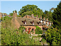
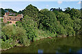
Riverside housing at Upper Arley, Worcestershire
These terraces are on the steep slopes to the north side of the river.
Image: © Roger D Kidd
Taken: 28 Sep 2011
0.03 miles
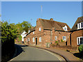
2
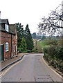
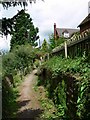
Arley Lane
The village street at Upper Arley is sometimes referred to as Arley Lane. It descends down to the river (as in this view), runs in sight of the river for a short distance, then climbs again up to a turning circle where the drive to the Parish Church and the entrance to the Arboretum are located.Image
Image: © P L Chadwick
Taken: 30 Dec 2008
0.04 miles
4
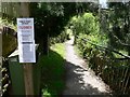
Closed due to flood damage
This is the Severn Way public footpath at Upper Arley, closed due to part of the path being washed away at: Image
Image: © Mat Fascione
Taken: 9 Jul 2007
0.04 miles
5
River Severn (north bank) at Upper Arley, Worcestershire
The outside bend of the meander has resulted in a very steep river bank here south-east of the village. It is kept well wooded to encourage srtability. The Severn Way footpath passes through the trees towards Timperley Reservoir.
Image: © Roger Kidd
Taken: 20 Sep 2021
0.04 miles
6
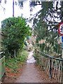
Severn Way at Upper Arley
Public footpath as it enters Upper Arley.
Image: © Mat Fascione
Taken: 9 Jul 2007
0.05 miles
7
Severn Way
This long distance footpath runs along one side of the River Severn at Upper Arley. On the opposite bank the footpath is part of the North Worcestershire Path.
Image: © P L Chadwick
Taken: 30 Dec 2008
0.05 miles
8
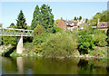
The River Severn at Upper Arley, Worcestershire
Looking north across the river towards the village. The truss footbridge across the River Severn was built in 1971. There used to be a vehicular ferry near here, but that stopped its service in 1972.
Image: © Roger D Kidd
Taken: 28 Sep 2011
0.05 miles
9
Arley Lane in Upper Arley, Worcestershire
Image: © Roger D Kidd
Taken: 28 Sep 2011
0.05 miles
10
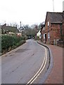
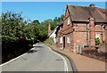
Arley Lane leading out of village
The only vehicular access to Upper Arley is by this road; here seen climbing up the hill out of the village. Eventually it connects to the A442 Kidderminster to Bridgnorth road.
Image: © P L Chadwick
Taken: 30 Dec 2008
0.05 miles