IMAGES TAKEN NEAR TO
Worcester Road, KIDDERMINSTER, DY11 7XA
Introduction
This page details the photographs taken nearby to Worcester Road, DY11 7XA by members of the Geograph project.
The Geograph project started in 2005 with the aim of publishing, organising and preserving representative images for every square kilometre of Great Britain, Ireland and the Isle of Man.

There are currently over 7.5m images from over14,400 individuals and you can help contribute to the project by visiting https://www.geograph.org.uk
Image Map (Loading...)


Getting Data...Please wait
Leaflet Map data © OpenStreetMap
Images are licensed for reuse under creativecommons.org/licenses/by-sa/2.0
Notes
- Clicking on the map will re-center to the selected point.
- The higher the marker number, the further away the image location is from the centre of the postcode.
Image Listing (10 Images Found)
Images are licensed for reuse under creativecommons.org/licenses/by-sa/2.0
Image
Details
Distance
1
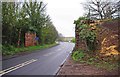
Former trackbed
Looking towards (the former) Hartlebury junction on the line that went to Bewdley (on the preserved Severn Valley Railway) via Stourport on Severn.
Image: © Jennifer Luther Thomas
Taken: 14 Nov 2006
0.11 miles
3

Northern end of Rectory Lane
The original route north from Hartlebury drops to meet the newer A449.
Image: © Peter Whatley
Taken: 26 Oct 2011
0.17 miles
5
A449 passes between former railway bridge piers
Image: © Colin Pyle
Taken: 20 Jun 2013
0.21 miles
6

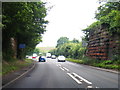
Worcester Road
The A449 passing the abutments of the former bridge which carried the now-disused railway line over the road.
Image: © David Dixon
Taken: 18 May 2023
0.21 miles
7
Remains of former railway bridge over A449 road, near Hartlebury
This partially dismantled bridge over the A449 road (Worcester Road) used to carry the branch railway from Hartlebury to Stourport-on-Severn. In the distance, where the car is, the B4193 road (Rectory Lane) branches off to Hartlebury.
Image: © P L Chadwick
Taken: 7 Apr 2012
0.21 miles
8
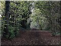
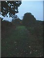
Path along a former railway line
The route of a former railway line to Stourport-on-Severn. It now forms part of a linear country park called Leapgate Country Park.
Image: © Mat Fascione
Taken: 12 Nov 2022
0.23 miles
9
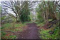
Near the end of the path along the former branch railway line, near Hartlebury
This path has come from Stourport-on-Severn and is constructed along part of the route of the former Hartlebury to Stourport-on-Severn railway line. In this view the path can be seen making a left turn, it then goes a very short distance to descend to the very busy A449 road. Ahead is a short path which leads to the remains of the former railway bridge. At that point it is sealed off, as the part of the bridge crossing the road has been removed. See:- Image
Image: © P L Chadwick
Taken: 7 Apr 2012
0.24 miles
10
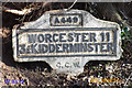
Old Milestone by the A449, Torton, Hartlebury parish
Metal plates attached to concrete post by the A449, in parish of HARTLEBURY (WYCHAVON District), North of old railway bridge, on hedge bank behind footpath, on East side of road, near 'Please Slow' sign. Bradley post, erected by the County Council in the 20th century.
Inscription reads:-
A449
WORCESTER 11
3¼ KIDDERMINSTER
C.C.W.
Milestone Society National ID: WO_WOKD11.
Image: © J Higgins
Taken: 28 Aug 2011
0.25 miles