IMAGES TAKEN NEAR TO
Queen Street, SHERBORNE, DT9 6LL
Introduction
This page details the photographs taken nearby to Queen Street, DT9 6LL by members of the Geograph project.
The Geograph project started in 2005 with the aim of publishing, organising and preserving representative images for every square kilometre of Great Britain, Ireland and the Isle of Man.

There are currently over 7.5m images from over14,400 individuals and you can help contribute to the project by visiting https://www.geograph.org.uk
Image Map
Images are licensed for reuse under creativecommons.org/licenses/by-sa/2.0
Notes
- Clicking on the map will re-center to the selected point.
- The higher the marker number, the further away the image location is from the centre of the postcode.
Image Listing (235 Images Found)
Images are licensed for reuse under creativecommons.org/licenses/by-sa/2.0
Image
Details
Distance
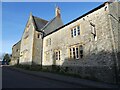
1
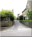
Queen Street, Yetminster
Cul-de-sac on the south side of High Street.
Image: © Jaggery
Taken: 6 Jun 2015
0.01 miles
2
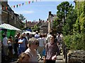
Yetminster High Street during the annual fair day
Yetminster - home of the Yetties folk band
Image: © Ivan Taylor
Taken: 12 Jul 2003
0.04 miles
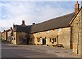
3
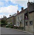
High Street bus stop, Yetminster
Outside the White Hart. http://www.geograph.org.uk/photo/4513428
Image: © Jaggery
Taken: 6 Jun 2015
0.04 miles
4
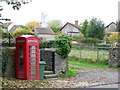
Telephone box, Yetminster
A K6 type telephone box on the High Street.
Image: © Maigheach-gheal
Taken: 31 Oct 2009
0.05 miles
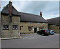
6
White Hart pub, Yetminster
This free house has been built from local stone and dates from the late 16th century.
It has been Grade II listed since 1951.
Image: © mike smith
Taken: 28 Oct 2014
0.05 miles
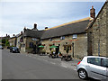
7
White Hart, Yetminster
Dating from c1600, the thatched pub is one of many Listed Buildings in Yetminster High Street.
Image: © Jaggery
Taken: 6 Jun 2015
0.05 miles
8
The White Hart
In High Street, Yetminster.
Image: © John Lucas
Taken: 13 Jul 2017
0.05 miles
9
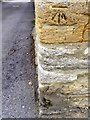
Bench Mark, Petties Farm
The Ordnance Survey is to be found on the south face of the building. For a wider view Image and for further information on the cut mark and others in the area http://www.bench-marks.org.uk/bm38434
Image: © Maigheach-gheal
Taken: 24 Jun 2011
0.05 miles
10
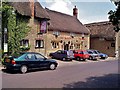
Yetminster: The White Hart
Early digital photo of the White Hart, Yetminster, Dorset. The village home of the folk group "The Yetties"
Image: © Mr Eugene Birchall
Taken: 12 Jul 1999
0.05 miles