IMAGES TAKEN NEAR TO
Glacis, PORTLAND, DT5 1FR
Introduction
This page details the photographs taken nearby to Glacis, DT5 1FR by members of the Geograph project.
The Geograph project started in 2005 with the aim of publishing, organising and preserving representative images for every square kilometre of Great Britain, Ireland and the Isle of Man.

There are currently over 7.5m images from over14,400 individuals and you can help contribute to the project by visiting https://www.geograph.org.uk
Image Map
Images are licensed for reuse under creativecommons.org/licenses/by-sa/2.0
Notes
- Clicking on the map will re-center to the selected point.
- The higher the marker number, the further away the image location is from the centre of the postcode.
Image Listing (102 Images Found)
Images are licensed for reuse under creativecommons.org/licenses/by-sa/2.0
Image
Details
Distance
1
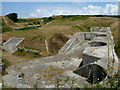
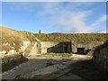
Gun emplacements at High Angle Battery
Near the highest point on Portland, these gun emplacements were built in a hidden position, firing high into the air in the hope of smashing shells through the decks of any enemy ship attacking Weymouth harbour. They were only in service for 12 years around the turn of the 20th century. Ammunition was stored in tunnels and supplied to the guns via a narrow gauge railway, visible running along ground level, through the arch, then up a ramp at the back, across the bridge and along the front wall to feed the front loading guns.
The arch visible in the background is the entrance to The Verne barracks (now prison) where the gun crews lived.
Surprisingly the construction is in concrete, not portland stone, and is crumbling in places.
Image: © John Goldsmith
Taken: 5 Jul 2009
0.03 miles
2
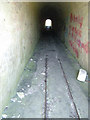
Ammunition access tunnel, High Angle Battery
The ammunition for the High Angle Battery (See Image) was stored underground, with a narrow gauge railway running down this tunnel, which then has side branches into the stone hillside.
Image: © John Goldsmith
Taken: 5 Jul 2009
0.03 miles
3
Part of former gun battery, Verne
The colour of the sky accurately reflects the approaching thunderstorm.
Image: © David Martin
Taken: 1 May 2017
0.05 miles
4
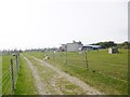
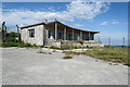
Grove, farmhouse
Home of Fancys Family Farm, with animals, poultry, play area and café: http://www.fancysfarm.co.uk/ The bungalow is reputed to have a nuclear bunker.
Image: © Mike Faherty
Taken: 13 Sep 2014
0.05 miles
5
Rotor bungalow
For those seeking the truth behind the many rumours of hidden passages and bunkers on the Isle of Portland this unassuming bungalow may hold the answer. Inside is a (securely sealed) entrance to a ROTOR bunker that lies 100 feet below ground level. Access is not currently possible. More on ROTOR: http://www.subbrit.org.uk/rsg/features/rotor/
Image: © Noel Jenkins
Taken: Unknown
0.05 miles
6
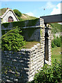
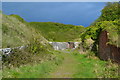
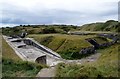
Entrance fortifications, The Verne
The builders of The Verne Battery and Barracks (now prison) seemed to be seriously worried about land attack from the rear, and built this very deep moat, and then a long access tunnel after the main doors. I guess there was originally a removable bridge, and there are traces of previous engineering below the more recent concrete bridge.
Image: © John Goldsmith
Taken: 5 Jul 2009
0.06 miles
8
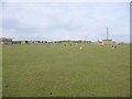
Grove, sheep grazing
Portland sheep at Fancys Family Farm, on a former defence site. http://www.fancysfarm.co.uk/
Image: © Mike Faherty
Taken: 13 Sep 2014
0.07 miles
9
High Angle Battery, Verne, Portland, Dorset
A Victorian Coastal Defence Emplacement 1800, constructed in former stone quarry.
The name comes from type of guns used in relation to the 'low' level appearance.
Magazines housed in surrounding banking with a railway linking them to the guns.
Image: © D M Wilmot
Taken: 27 Aug 2011
0.07 miles
10
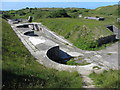
Verne High Angle Battery
The Verne was built around 1892, and housed six 9-inch cannons.
Image: © Gareth James
Taken: 10 Jun 2017
0.07 miles