IMAGES TAKEN NEAR TO
Tadnoll, DORCHESTER, DT2 8DS
Introduction
This page details the photographs taken nearby to Tadnoll, DT2 8DS by members of the Geograph project.
The Geograph project started in 2005 with the aim of publishing, organising and preserving representative images for every square kilometre of Great Britain, Ireland and the Isle of Man.

There are currently over 7.5m images from over14,400 individuals and you can help contribute to the project by visiting https://www.geograph.org.uk
Image Map
Images are licensed for reuse under creativecommons.org/licenses/by-sa/2.0
Notes
- Clicking on the map will re-center to the selected point.
- The higher the marker number, the further away the image location is from the centre of the postcode.
Image Listing (10 Images Found)
Images are licensed for reuse under creativecommons.org/licenses/by-sa/2.0
Image
Details
Distance
1
![Tadnoll area [4]](https://s0.geograph.org.uk/geophotos/07/25/39/7253924_962683aa_120x120.jpg)
Tadnoll area [4]
Redbridge Road, looking north from near Tadnoll Hill Farm.
Image: © Michael Dibb
Taken: 30 May 2022
0.04 miles
2
![Tadnoll area [3]](https://s3.geograph.org.uk/geophotos/07/25/39/7253923_3f777321_120x120.jpg)
Tadnoll area [3]
A field alongside Redbridge Road, seen from near Tadnoll Hill Farm.
Image: © Michael Dibb
Taken: 30 May 2022
0.08 miles
4
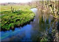
Tadnoll Mill Stream
This is the view SW upstream , about 100m above the mill itself.
Image: © Nigel Mykura
Taken: 22 Mar 2009
0.09 miles
5
![Tadnoll area [1]](https://s1.geograph.org.uk/geophotos/07/25/39/7253921_185a9ab0_120x120.jpg)
Tadnoll area [1]
Tadnoll Hill Farm, seen from Redbridge Road.
Image: © Michael Dibb
Taken: 30 May 2022
0.09 miles
6
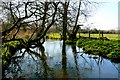
Tadnoll Mill Stream
The stream above the mill has been banked up to allow a good reservoir of water to build up for the mill and the mill stream was noticeably fuller of water than other local streams. This is about 100m upstream of the mill.
Image: © Nigel Mykura
Taken: 22 Mar 2009
0.11 miles
7
![Tadnoll area [2]](https://s2.geograph.org.uk/geophotos/07/25/39/7253922_4ae598ee_120x120.jpg)
Tadnoll area [2]
Redbridge Road, looking south from near Tadnoll Hill Farm. Tadnoll Cottages are seen on the right.
Image: © Michael Dibb
Taken: 30 May 2022
0.12 miles
9
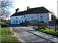
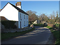
Tadnoll Mill and Mill House
Probably C18 and Grade II listed, that was extended to the west in the C19 (dated 1841).
Image: © Mike Searle
Taken: 21 Mar 2007
0.15 miles
10
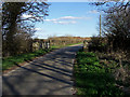
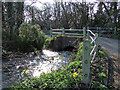
Bridge Over Frome Tributary at Tadnoll
Image: © Mike Searle
Taken: 21 Mar 2007
0.16 miles