IMAGES TAKEN NEAR TO
Higher Wraxall, DORCHESTER, DT2 0HR
Introduction
This page details the photographs taken nearby to DT2 0HR by members of the Geograph project.
The Geograph project started in 2005 with the aim of publishing, organising and preserving representative images for every square kilometre of Great Britain, Ireland and the Isle of Man.

There are currently over 7.5m images from over14,400 individuals and you can help contribute to the project by visiting https://www.geograph.org.uk
Image Map
Images are licensed for reuse under creativecommons.org/licenses/by-sa/2.0
Notes
- Clicking on the map will re-center to the selected point.
- The higher the marker number, the further away the image location is from the centre of the postcode.
Image Listing (9 Images Found)
Images are licensed for reuse under creativecommons.org/licenses/by-sa/2.0
Image
Details
Distance
1
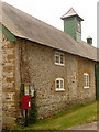
Wraxall: postbox № DT2 205, Higher Wraxall
This little postbox and neighbouring parish noticeboard stand against the outbuildings by the manor house (see Image). The box is emptied daily, except Sunday, at 10:30am.
Image: © Chris Downer
Taken: 2 Jul 2009
0.06 miles
3
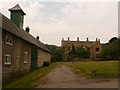
Wraxall: manor house and outbuildings
A wider view of Image, taking in the building alongside, a large barn with a clock on top – belonging either to the manor house or to its neighbour, Manor Farm.
Image: © Chris Downer
Taken: 2 Jul 2009
0.08 miles
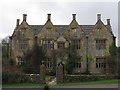
4
Wraxall: the manor house
A picturesque sandstone building in Higher Wraxall.
Image: © Chris Downer
Taken: 2 Jul 2009
0.09 miles
5
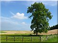
Magnificent Ash tree Higher Wraxall
This fine specimen stands just outside the hamlet of Higher Wraxall on the road that runs SW up the hill to the Kingcombe crossroads on the A356 Dorchester to crewkerne road.
Image: © Nigel Mykura
Taken: 10 Jun 2008
0.10 miles
6
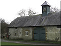
Clock on barn at Manor Farm, Higher Wraxall
Image: © Becky Williamson
Taken: 4 Jan 2018
0.10 miles
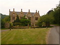
7
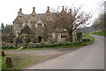
Manor House at Higher Wraxall
Wraxall is divided into two tiny hamlets. Higher Wraxall has this fine large stone manor house, built around 1630 and extended in the 19th century, with a few cottages and a farm.
Image: © John Lamper
Taken: 23 Apr 2006
0.11 miles
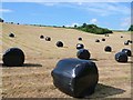
8
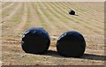
Wrapped hay bales. Higher Wraxall
These bales were lying close to the road that runs from Kingcombe cross roads to the tiny hamlet of Higher Wraxall
Image: © Nigel Mykura
Taken: 10 Jun 2008
0.19 miles
9
Wrapped bales, Higher Wraxall
View looking north from the road from Higher Wraxall to the Kingcombe Crossroads on the A356. The recently harvested and wrapped bales of hay await collection.
Image: © Nigel Mykura
Taken: 10 Jun 2008
0.21 miles