IMAGES TAKEN NEAR TO
Hadwidia Court, DT1 3FZ
Introduction
This page details the photographs taken nearby to Hadwidia Court, DT1 3FZ by members of the Geograph project.
The Geograph project started in 2005 with the aim of publishing, organising and preserving representative images for every square kilometre of Great Britain, Ireland and the Isle of Man.

There are currently over 7.5m images from over14,400 individuals and you can help contribute to the project by visiting https://www.geograph.org.uk
Image Map
Images are licensed for reuse under creativecommons.org/licenses/by-sa/2.0
Notes
- Clicking on the map will re-center to the selected point.
- The higher the marker number, the further away the image location is from the centre of the postcode.
Image Listing (11 Images Found)
Images are licensed for reuse under creativecommons.org/licenses/by-sa/2.0
Image
Details
Distance
1
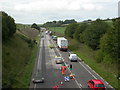
Dorchester Bypass
A37 near Poundbury, with re-surfacing requiring single-lane traffic.
Image: © Mike Faherty
Taken: 15 Sep 2009
0.17 miles
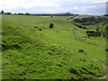
3
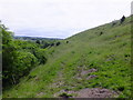
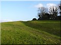
Roman Aqueduct, near Poundbury Hill fort
Although the aqueduct followed the course of the River Frome, it had to follow an almost level course (rising at 275ft and arriving in Dorchester at 260ft) and so had to run into the smaller "spur" valleys of the Frome. Here at Fordington Bottom the aqueduct does just that and runs up the spur valley for almost half a mile before making a "U" turn and heading back down the other side of the spur.
Image: © Ian Andrews
Taken: 21 Jun 2013
0.19 miles
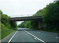
4
A37 Dorchester Bypass and Roman Aqueduct
This picture was taken from the Poundbury Road bridge over the A37. You are looking South West up (excuse me) Fordington Bottom. You can see the course of the Roman aqueduct as it goes along the hedge-line half way up the grassy bank on the right of the road. it would have crossed the valley floor at a point a little beyond the bend in the road and run back down Fordington Bottom on the left of the road about half way up the bank on the right, maintaining a height above sea level of around 265ft all the way around.
Image: © Ian Andrews
Taken: 21 Jun 2013
0.20 miles
5
Remains of Roman aqueduct for Dorchester
Image: © Becky Williamson
Taken: 20 Feb 2016
0.20 miles
6

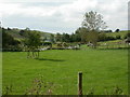
New housing, Dorchester
A development called Poundbury, named after Poundbury Farm, which survives in the middle. The farm in turn was named after the ancient fort, some way behind the camera.
Image: © Robin Webster
Taken: 4 Jun 2017
0.21 miles
7
Poundbury, allotments & goats
Whitfield Rural Activities Centre, offering work placements and support for people with mental health problems, organised by the National Care Farms Initiative. Scroll down to Farm Placement Scheme at http://www.farmradio.org.uk/programs_edition42.htm
Image: © Mike Faherty
Taken: 15 Sep 2009
0.22 miles
8
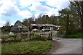
Whitfield Shop
A greenhouse fronting an area of market garden; also on the site is, according to a notice,a rural activities centre.On Roman Road, between Dorchester and Bradford Peverell.
Image: © Peter Barr
Taken: 27 Apr 2013
0.22 miles
9
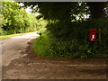
Bradford Peverell: postbox № DT2 145, Whitfield
This George VI-reign postbox is emptied at 11 o'clock each weekday and Saturday morning.
Image: © Chris Downer
Taken: 7 Jun 2009
0.23 miles
10
Course of the Dorchester Roman Aqueduct
Looking NW along the course of the Roman aqueduct which carried water to the settlement at Dorchester (Dvrnovaria). The River Frome valley is on the right of the picture and the A37 bypass which cuts diagonally across this grid square is well hidden in a cutting.
Image: © Jim Champion
Taken: 2 Jun 2005
0.24 miles