IMAGES TAKEN NEAR TO
Talbothays Road, DORCHESTER, DT1 2SY
Introduction
This page details the photographs taken nearby to Talbothays Road, DT1 2SY by members of the Geograph project.
The Geograph project started in 2005 with the aim of publishing, organising and preserving representative images for every square kilometre of Great Britain, Ireland and the Isle of Man.

There are currently over 7.5m images from over14,400 individuals and you can help contribute to the project by visiting https://www.geograph.org.uk
Image Map (Loading...)


Getting Data...Please wait
Leaflet Map data © OpenStreetMap
Images are licensed for reuse under creativecommons.org/licenses/by-sa/2.0
Notes
- Clicking on the map will re-center to the selected point.
- The higher the marker number, the further away the image location is from the centre of the postcode.
Image Listing (11 Images Found)
Images are licensed for reuse under creativecommons.org/licenses/by-sa/2.0
Image
Details
Distance
1
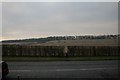
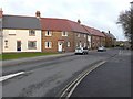
Reaching the A35 ring road, Dorchester
The footpath across the fields to the North Plantation can be seen in the distance.
Image: © Becky Williamson
Taken: 6 Feb 2015
0.12 miles
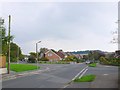
2
Moynton Rd
A modern housing development on the site of the old Thomas Hardye School.
Image: © Nigel Mykura
Taken: 4 Jan 2011
0.15 miles
3

St Mary's Catholic VA First school, Dorchester
Image: © Becky Williamson
Taken: 11 Aug 2016
0.19 miles
4
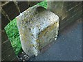
Street stone
An unusual stone on the edge of the street. The front would have appeared to have a plaque missing indicating what it was for, possibly a mile stone on an old lane. The second point of interest is the Ordnance Survey cut bench mark on the side. The builders of the wall had made a wise decision not to brick it in but to construct an arch over it, so they must have identified it was a stone of some importance.
Image: © Mat Tuck
Taken: 6 Aug 2014
0.20 miles
5
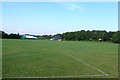
Sandringham Sports field , Dorchester
These playing fields are part of the Sandringham sports centre and are close to where the old Thomas Hardye School used to stand.
Image: © Nigel Mykura
Taken: 26 Jul 2008
0.20 miles
6
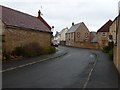
Lucetta Lane Dorchester
One of the many roads that are named after Thomas Hardy characters. Lucette Le Sueur is a french speaking woman from Jersey in the novel The Mayor of Casterbridge. She is the lover of Henchard who is the mayor in the title of the book. This photo was taken from close to the junction with South Court Avenue and Culliford Rd.
Image: © Nigel Mykura
Taken: 19 Jan 2010
0.21 miles
7
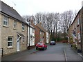
Ivel Close
This is one of the short residential streets built on the site of the old Thomas Hardye School. The trees at the end mark the pedestrian section of Barnes Way. The housing development resulted in a large central part of Barnes way disappearing leaving two unconnected sections at either end and also this small pedestrian pathway.
Image: © Nigel Mykura
Taken: 4 Jan 2011
0.21 miles
8
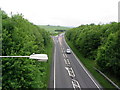
Dorchester bypass
The A35 looking west towards the junction with the A352.
Image: © Stephen Williams
Taken: 16 May 2007
0.21 miles
9
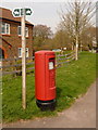
Dorchester: postbox № DT1 163, Buckingham Way
This modern postbox is emptied finally at 5:15pm on weekdays and at 11:30pm on Saturdays.
Image: © Chris Downer
Taken: 10 Apr 2010
0.23 miles
10
Barnes Way Dorchester
The junction with Rothesay Rd with St Osmunds School in the background.
Image: © Nigel Mykura
Taken: 15 Sep 2008
0.24 miles