IMAGES TAKEN NEAR TO
Wyvern Road, DORCHESTER, DT1 2PW
Introduction
This page details the photographs taken nearby to Wyvern Road, DT1 2PW by members of the Geograph project.
The Geograph project started in 2005 with the aim of publishing, organising and preserving representative images for every square kilometre of Great Britain, Ireland and the Isle of Man.

There are currently over 7.5m images from over14,400 individuals and you can help contribute to the project by visiting https://www.geograph.org.uk
Image Map
Images are licensed for reuse under creativecommons.org/licenses/by-sa/2.0
Notes
- Clicking on the map will re-center to the selected point.
- The higher the marker number, the further away the image location is from the centre of the postcode.
Image Listing (31 Images Found)
Images are licensed for reuse under creativecommons.org/licenses/by-sa/2.0
Image
Details
Distance
1
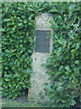
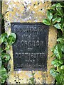
Dorchester: boundary stone on Poundbury Road
The metal plate is dated 1900 and marks the "Boundary of the Borough of Dorchester" - clearly the borough or parish has expanded since those times, although it still accurately marks the extent of the built-up area.
Image: © Chris Downer
Taken: 10 Mar 2015
0.04 miles
5
Old ROC nuclear monitoring post, Poundbury
One of the very common underground Royal Observer Corps bunkers built during the cold war.
Image: © Robin Webster
Taken: 4 Jun 2017
0.06 miles
6
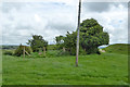
Poundbury Hill Fort, Dorchester
Poundbury Hill is the site of a Middle Bronze Age fort or enclosure. It is roughly rectangular and it is likely that it was designed to command views over the River Frome and the Frome valley to the north. The main entrance to the fort is on the eastern end. It overlooks the county town of Dorchester. (Source: Wikipedia)
Image: © Becky Williamson
Taken: 15 Feb 2015
0.06 miles
7
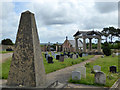
Poundbury Cemetery
Established in the 1990s, this has some unusual features, such as the temple-like building. This has a chamber beneath it for shared deposition of ashes.
Image: © Robin Webster
Taken: 4 Jun 2017
0.07 miles
8
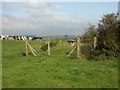
Poundbury, ROC post
Remains of the Royal Observer Corps post just outside the hillfort; for a contemporary WW2 picture, see http://www.dorsetlife.co.uk/articles/ArticlesDetail.asp?ID=666
Image: © Mike Faherty
Taken: 15 Sep 2009
0.07 miles
9
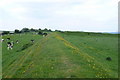
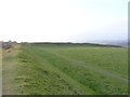
Poundbury Hill Fort
This is the southern ramparts looking west of the rectangular shaped earth-built structure which dates from the middle bronze age c 1500BC. The northern side was badly damaged by the Romans building an aqueduct for Dorchester.
Image: © Nigel Mykura
Taken: 20 May 2008
0.07 miles
10
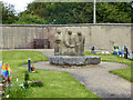
Children's corner, Poundbury Cemetery
Image: © Robin Webster
Taken: 4 Jun 2017
0.07 miles