IMAGES TAKEN NEAR TO
Colliton Park, DORCHESTER, DT1 1XJ
Introduction
This page details the photographs taken nearby to Colliton Park, DT1 1XJ by members of the Geograph project.
The Geograph project started in 2005 with the aim of publishing, organising and preserving representative images for every square kilometre of Great Britain, Ireland and the Isle of Man.

There are currently over 7.5m images from over14,400 individuals and you can help contribute to the project by visiting https://www.geograph.org.uk
Image Map
Images are licensed for reuse under creativecommons.org/licenses/by-sa/2.0
Notes
- Clicking on the map will re-center to the selected point.
- The higher the marker number, the further away the image location is from the centre of the postcode.
Image Listing (620 Images Found)
Images are licensed for reuse under creativecommons.org/licenses/by-sa/2.0
Image
Details
Distance
1
The Roman Town House and Dorset County Hall, Dorchester
Image: © David Smith
Taken: 22 Jun 2010
0.02 miles
2
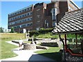
Art Deco/Modernist Council Offices, Dorchester, Dorset
The foundation stone was laid on 26 September 1938 by the Earl of Shaftesbury. The architect was H E Matthews. However, the outbreak of war delayed the completion until 1955 when the Lord Bishop Suffragan of Sherborne laid the dedication stone on 27 May 1955. The stones are either side of the entrance steps. It looks like there may have been flag poles on the front of the building (or plans for these).
The main building seen in the photograph contains the court house on the left side and the reception area in the centre of the block, which retains much of its Art Deco feel. There is then a passage from behind the reception area that connects to another building behind (it can just be seen to the left). This building has 3 wings that go to the left, right and ahead. At the junction is an Art Deco circular stairwell with a lift in the centre. Many of the rooms in these blocks have the metal Crittall windows.
Image: © Alan Cooper
Taken: Unknown
0.03 miles
3
Art Deco/Modernist Council Offices, Dorchester, Dorset - detail
See Image for a description.
Image: © Alan Cooper
Taken: Unknown
0.03 miles
4
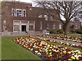
Dorchester - County Hall
Art Deco style County Hall.
Image: © Chris Talbot
Taken: 1 Apr 2012
0.04 miles
5
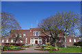
Dorchester, County Hall
The main building, off Glyde Path Road; once the gardens of Colliton House.
Image: © Mike Faherty
Taken: 15 Sep 2009
0.04 miles
6
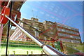
Roman Town House, County hall, Dorchester
The roman town house is in the grounds of Dorset County Hall. The remains of the house are protected by a red steel framed, glass sided shelter. This is a view looking through one of the glass side walls with County Hall and the blue skies above reflected in it. If one ignores county hall one can see the internal structure of the shelter roof and at lower right part of an internal roman house wall. The steel rod in the foreground is a diagonal stabilising stay in the side wall of the shelter.
Image: © Nigel Mykura
Taken: 25 May 2008
0.04 miles
7
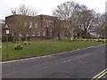
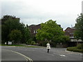
Northernhay, Dorchester
Looking east along the path that runs along the northern edge of Colliton Park (right). To the left is the road known as Northernhay. In the distance can be seen the scaffolding-clad chimneys of the Victorian HMP Dorchester.
Image: © DorsetBlogger
Taken: 29 Mar 2008
0.04 miles
9
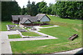
Dorchester Roman Town House
The remains of this house were found in 1937. It dates to the 4thC AD, very late in the Roman occupation of Britain. Beautiful mosaics were found in part of the house and this part was covered with a steel and glass roof. It is located in the grounds of County Hall and never seems to have any visitors.
Image: © Nigel Mykura
Taken: 25 May 2008
0.05 miles
10
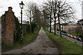
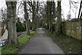
Colliton Walk, Dorchester
Dorchester's walks follow the lines of the roman walls. This was taken at the north-eastern corner of the roman town. The road on the right is known as The Grove.
Image: © DorsetBlogger
Taken: 29 Mar 2008
0.05 miles