IMAGES TAKEN NEAR TO
Glyde Path Road, DORCHESTER, DT1 1XD
Introduction
This page details the photographs taken nearby to Glyde Path Road, DT1 1XD by members of the Geograph project.
The Geograph project started in 2005 with the aim of publishing, organising and preserving representative images for every square kilometre of Great Britain, Ireland and the Isle of Man.

There are currently over 7.5m images from over14,400 individuals and you can help contribute to the project by visiting https://www.geograph.org.uk
Image Map
Images are licensed for reuse under creativecommons.org/licenses/by-sa/2.0
Notes
- Clicking on the map will re-center to the selected point.
- The higher the marker number, the further away the image location is from the centre of the postcode.
Image Listing (804 Images Found)
Images are licensed for reuse under creativecommons.org/licenses/by-sa/2.0
Image
Details
Distance
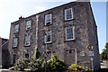
1
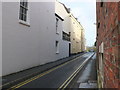
Shire Hall Lane, Dorchester
A small lane running north off High West St this is also known as Glyde Path Rd and Thomas Hardy once lived here.The redbricks are the side wall of the Shire Hall.
Image: © Nigel Mykura
Taken: 1 Apr 2008
0.01 miles
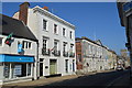
2
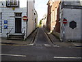
Glyde Path Road
Formerly Shire Hall Lane. The Council offices are situated up on the left.
Image: © Anthony Vosper
Taken: 30 Oct 2012
0.02 miles
3
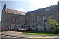
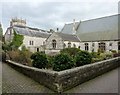
Colliton House, Glyde Path Road, Dorchester
Grade II* Listed house with demolished outhouse containing a datestone of 1729 probably reflecting the later alterations. The information plaque reads 'Formerly the town house of the Churchill family. Mainly 17th century with major 18th century alterations. The site is believed to be the location of the medieval hospital of St John the Baptist fragments of which may still remain in the building and its foundations. The building has been owned by the County Council since 1933.'
Image: © Jo and Steve Turner
Taken: 6 Sep 2007
0.02 miles
4
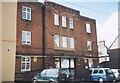
Art Deco, Glyde Path House, Glyde Path Road, Dorchester
On first seeing this building I thought it was an old art deco cinema but I cannot find any records to show this and a Google satellite view shows an inner courtyard. The building is currently occupied by the Inland Revenue.
Image: © Alan Cooper
Taken: Unknown
0.02 miles
5
Colliton House, Glyde Path Road, Dorchester
Grade II* Listed house with demolished outhouse containing a datestone of 1729 probably reflecting the later alterations. The information plaque reads 'Formerly the town house of the Churchill family. Mainly 17th century with major 18th century alterations. The site is believed to be the location of the medieval hospital of St John the Baptist fragments of which may still remain in the building and its foundations. The building has been owned by the County Council since 1933.'
Image: © Jo and Steve Turner
Taken: 6 Sep 2007
0.03 miles
6
57 High West Street
Offices of the Rifle Volunteers in 1911.
Image: © John M
Taken: 16 Sep 2014
0.03 miles
7
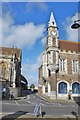
Dorchester: View of the Clock Tower on the corner of The Bow
Image: © Mr Eugene Birchall
Taken: 25 Oct 2009
0.03 miles
8
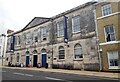
Shire Hall, Dorchester
View from south east. https://historicengland.org.uk/listing/the-list/list-entry/1119069
Image: © Sandy Gerrard
Taken: 2 Sep 2020
0.03 miles
9
Holy Trinity Church, Dorchester
This view of the Holy Trinity Church is taken from the rear in Grey School Passage.
Image: © Tom Jolliffe
Taken: 16 Feb 2012
0.03 miles
10
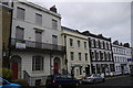
Buildings on High West Street
High West St is approximately on the line of the old roman road running west out of Dorchester towards Bridport. Most of the buildings are now offices and many of the shops in this row are estate agents.
Image: © Nigel Mykura
Taken: 14 Jan 2015
0.03 miles