IMAGES TAKEN NEAR TO
Nethergate, DONCASTER, DN9 2DJ
Introduction
This page details the photographs taken nearby to Nethergate, DN9 2DJ by members of the Geograph project.
The Geograph project started in 2005 with the aim of publishing, organising and preserving representative images for every square kilometre of Great Britain, Ireland and the Isle of Man.

There are currently over 7.5m images from over14,400 individuals and you can help contribute to the project by visiting https://www.geograph.org.uk
Image Map
Images are licensed for reuse under creativecommons.org/licenses/by-sa/2.0
Notes
- Clicking on the map will re-center to the selected point.
- The higher the marker number, the further away the image location is from the centre of the postcode.
Image Listing (19 Images Found)
Images are licensed for reuse under creativecommons.org/licenses/by-sa/2.0
Image
Details
Distance

2
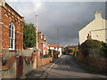
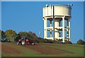
View up Nethergate
Nethergate climbs the hill towards the water tower.
Image: © Jonathan Thacker
Taken: 3 Nov 2011
0.13 miles
3
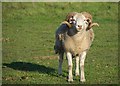
Westwoodside ram
In a field north of Sandbeds Lane, I sensed he was unlikely to stand for any of the nonsense tolerated by fellow locals such as the Image
Image: © Paul Harrop
Taken: 25 Oct 2016
0.14 miles
6
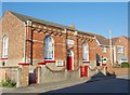
Methodist Chapel, Westwoodside
On Nethergate; the date stone reads 'Primitive Methodist Chapel 1861', apparently it was one of three chapels in the village but is now the only one still used as a place of worship.
(The Brethergate chapel was demolished for a new development. The Commonside chapel closed and eventually became a M.O.T service and repair garage and is still in use according to their advert - additional information courtesy of Dave Hitchborne http://www.geograph.org.uk/profile/4330 )
Image: © Paul Harrop
Taken: 25 Oct 2016
0.19 miles
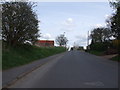
7
Tower and tractor between Haxey and Westwoodside
Seen from the footpath between the two villages, close to Sandbeds Farm
Image: © Paul Harrop
Taken: 25 Oct 2016
0.20 miles
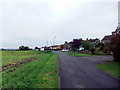
8
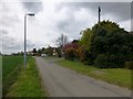
Tower Hill
Bagged the water tower then 13 and 14 Mill Lane.
Name: Tower Hill
Hill number: 16860
Height: 41m / 135ft
Parent (Ma/M): 2807 Kinder Scout
Section: 37: The River Tees to The Wash
County/UA: North Lincolnshire (UA)
Class: Tump (0-99m)
Grid ref: SK758999 (est)
Drop: 40m
Col: 1m
Image: © Rude Health
Taken: 2 May 2015
0.20 miles
9
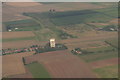
Haxey Water Tower from the South: aerial 2014
Haxey village is off shot to the right but the water tower is a prominent feature from the air, hence Haxey has been designated a VRP (Visual Reporting Point) for aircraft arriving and departing Doncaster Airport.
In practice aircraft, at least when flying east-west or west-east, seem to be asked to report simply when reaching the A1 or the River Trent.
Image: © Chris
Taken: 10 Sep 2014
0.20 miles
10
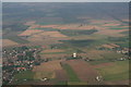
Haxey Water Tower from the South: aerial 2014
Haxey village is off shot to the right, with Upperthorpe and Westwoodside to the left (west). The water tower is a prominent feature from the air, hence Haxey has been designated a VRP (Visual Reporting Point) for aircraft arriving and departing Doncaster Airport.
In practice aircraft, at least when flying east-west or west-east, seem to be asked to report simply when reaching the A1 or the River Trent.
Image: © Chris
Taken: 10 Sep 2014
0.20 miles