IMAGES TAKEN NEAR TO
York Road, DONCASTER, DN5 8AN
Introduction
This page details the photographs taken nearby to York Road, DN5 8AN by members of the Geograph project.
The Geograph project started in 2005 with the aim of publishing, organising and preserving representative images for every square kilometre of Great Britain, Ireland and the Isle of Man.

There are currently over 7.5m images from over14,400 individuals and you can help contribute to the project by visiting https://www.geograph.org.uk
Image Map
Images are licensed for reuse under creativecommons.org/licenses/by-sa/2.0
Notes
- Clicking on the map will re-center to the selected point.
- The higher the marker number, the further away the image location is from the centre of the postcode.
Image Listing (73 Images Found)
Images are licensed for reuse under creativecommons.org/licenses/by-sa/2.0
Image
Details
Distance


3
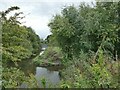
North end of the river Cheswold
The Cheswold is a 350 metre long connection between the river Don at this end and the Sheffield & South Yorkshire Navigation at the other; it may have been the original course of the Don before the navigation was created in the 18th century https://en.wikipedia.org/wiki/River_Cheswold .
Image: © Stephen Craven
Taken: 23 Sep 2023
0.05 miles
4
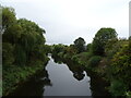
River Don
From the bridge on North Bridge Road.
Image: © JThomas
Taken: 19 Sep 2022
0.06 miles
5

Power Station Road bridge, Doncaster
The power station was demolished forty years ago, but the bridge still provides access to the remaining power infrastructure and Doncaster prison, both situated on the island between the rivers Don and Cheswold and the Sheffield & South Yorkshire Navigation.
Image: © Stephen Craven
Taken: 23 Sep 2023
0.06 miles
6
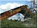
Breedon Aggregates, Doncaster (1)
Seen from the riverside path.
Image: © Stephen Craven
Taken: 23 Sep 2023
0.07 miles
7
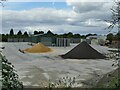
Breedon Aggregates, Doncaster (2)
Seen from the riverside path.
Image: © Stephen Craven
Taken: 23 Sep 2023
0.09 miles
8
A Doncaster & District Angling Association Sign
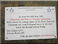
Image: © Ian S
Taken: 19 May 2012
0.09 miles
9

Three Horse Shoes, Doncaster
Viewed from St. Mary's Bridge, North Bridge Road.
Image: © John Topping
Taken: 4 Jun 2013
0.09 miles
10
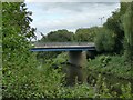
St Mary's Bridge, Doncaster
The modern road bridge over the River Don was opened by HRH The Princess Royal [Princess Mary, Countess of Harewood] on 27th November 1959. It replaced an earlier one of 1782, also called Mill Bridge; before that there was a medieval bridge with a chantry chapel dedicated to St Mary, hence the name.
Sources: https://greatnorthroad.co.uk/river-don ; https://player.bfi.org.uk/free/film/watch-building-of-st-marys-bridge-1959-online (with cine film).
Image: © Stephen Craven
Taken: 23 Sep 2023
0.09 miles