IMAGES TAKEN NEAR TO
Hooton Pagnell, DONCASTER, DN5 7BW
Introduction
This page details the photographs taken nearby to DN5 7BW by members of the Geograph project.
The Geograph project started in 2005 with the aim of publishing, organising and preserving representative images for every square kilometre of Great Britain, Ireland and the Isle of Man.

There are currently over 7.5m images from over14,400 individuals and you can help contribute to the project by visiting https://www.geograph.org.uk
Image Map
Images are licensed for reuse under creativecommons.org/licenses/by-sa/2.0
Notes
- Clicking on the map will re-center to the selected point.
- The higher the marker number, the further away the image location is from the centre of the postcode.
Image Listing (146 Images Found)
Images are licensed for reuse under creativecommons.org/licenses/by-sa/2.0
Image
Details
Distance
1
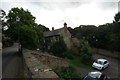
Barn Conversion
This is a 17th century barn, although not apparently listed. The stepped roof shows where it is divided: the nearer end is now part of the property known as Ivy Cottage, and the further end part of the property known as Wheatcroft House (Image)
Image: © Bob Harvey
Taken: 9 Sep 2016
0.03 miles
2
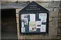
Village notice board
Image: © Bob Harvey
Taken: 9 Sep 2016
0.03 miles
3
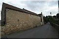
Wheatcroft House
Built in the 17th century as a house, converted later to two cottages and then extensively rebuilt in the 19th century as a single dwelling, this is a grade II listed building. See https://www.historicengland.org.uk/listing/the-list/list-entry/1192538
Image: © Bob Harvey
Taken: 9 Sep 2016
0.03 miles
4
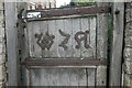
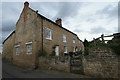
Gate at Wheatcroft House
This is something of a guess, but I suspect that the initials stand for "Warde-Norbury Agriculture", which seems to be the trading name of the estate farming enterprise.
Image: © Bob Harvey
Taken: 9 Sep 2016
0.03 miles
5
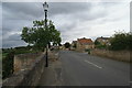
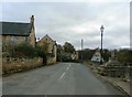
Village street
The buttercross is on the left.
I am not at all sure what the road name is here. it might be "Elmsall Lane" or it might not. The map associated with the National Heritage List give it as "Main Street" but no other mapping sites name it at all.
Image: © Bob Harvey
Taken: 9 Sep 2016
0.03 miles
7
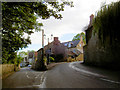
South Yorkshire or the Cotswolds?
I guess not everyone's view of South Yorkshire.
Image: © Steve Fareham
Taken: 20 Aug 2007
0.03 miles
8
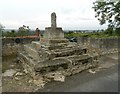
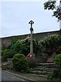
Old Central Cross by the B6422, Main Street, Hooton Pagnell parish
The Butter Cross, old shaft, base and steps by the B6422, in parish of Hooton Pagnell (Doncaster District), Main Street, Northwest of Ivy Cottage, in a large alcove in retaining wall overlooking the valley.
Grade II listed.
List Entry Number: 1151639 https://historicengland.org.uk/listing/the-list/list-entry/1151639
Scheduled Monument.
List Entry Number: 1012937 https://historicengland.org.uk/listing/the-list/list-entry/1012937
Surveyed
Milestone Society National ID: YSDN_HOO
Image: © Alan Rosevear
Taken: 23 Sep 2012
0.03 miles
9
Hooton Pagnell
The butter cross on the right of picture roughly marks the centre of this highly attractive, ancient village.
Image: © Jonathan Clitheroe
Taken: 12 Nov 2015
0.03 miles