IMAGES TAKEN NEAR TO
Pelham Square, CLEETHORPES, DN35 7JY
Introduction
This page details the photographs taken nearby to Pelham Square, DN35 7JY by members of the Geograph project.
The Geograph project started in 2005 with the aim of publishing, organising and preserving representative images for every square kilometre of Great Britain, Ireland and the Isle of Man.

There are currently over 7.5m images from over14,400 individuals and you can help contribute to the project by visiting https://www.geograph.org.uk
Image Map (Loading...)


Getting Data...Please wait
Leaflet Map data © OpenStreetMap
Images are licensed for reuse under creativecommons.org/licenses/by-sa/2.0
Notes
- Clicking on the map will re-center to the selected point.
- The higher the marker number, the further away the image location is from the centre of the postcode.
Image Listing (70 Images Found)
Images are licensed for reuse under creativecommons.org/licenses/by-sa/2.0
Image
Details
Distance
1

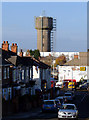
Pelham Road and the background the water tower
Image: © Steve Fareham
Taken: 12 Oct 2015
0.05 miles
2
Cleethorpes Water Tower
Photo taken from Grant Street near junction with Prince's Road.
Image: © David Wright
Taken: 18 Nov 2006
0.07 miles
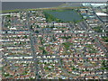
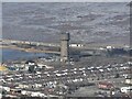
3
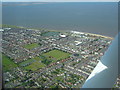
Cleethorpes 2007 (aerial): 4
Clee Road runs diagonally from the bottom left corner, past the playing field, to Isaac's Hill roundabout (by the white art deco former Electricity Board building).
The water tower is in the middle near the shoreline, with Blundell Park football ground top left.
Image: © John Hardy
Taken: 8 Aug 2007
0.07 miles
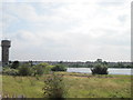
4
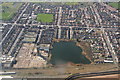
Chapman's Pond and the Water Tower, Cleethorpes: aerial 2015
Image: © Chris
Taken: 25 Mar 2015
0.07 miles
5
Water tower at Cleethorpes.
A walk along the prom.
Image: © steven ruffles
Taken: 9 Nov 2019
0.07 miles
6
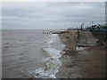
The beach, Cleethorpes
Near high tide.
Image: © Jonathan Thacker
Taken: 13 May 2016
0.08 miles
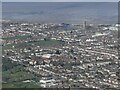
7
Cleethorpes 2007 (aerial): 3
The water tower is top right next to the "Fish Pond". Running right left are:
- the railway line (on the shoreline);
- Grimsby Road (this side of the pond); and
- Brereton Avenue (closest to the camera).
Image: © John Hardy
Taken: 8 Aug 2007
0.09 miles
8
Chapman's Pond and Water Tower
The legendary "bottomless" Chapman's Pond and Water Tower from north promenade. This century old landmark and surrounding land has been earmarked for residential development. It has an interesting history, according to its Facebook page the pond was "Originally a brick pit owned and dug by Walwyn Thomas Chapman and his family from 1881 until it was abandoned in 1915 when it was closed down due to fears that the light from the fires of the clay kilns would result in unwanted attention from German Zeppelins."
After workmen hit a spring in 1904 and the pit flooded it was sold to the local waterworks company who built the adjacent tower.
https://www.facebook.com/pages/Chapmans-Pond/122115547902232?v=info
Image: © Sue Adair
Taken: 30 Jul 2014
0.09 miles
9
Cleethorpes and water tower: aerial 2022 (1)
Image: © Simon Tomson
Taken: 6 Mar 2022
0.09 miles
10
Cleethorpes and water tower: aerial 2022 (2)
Image: © Simon Tomson
Taken: 6 Mar 2022
0.10 miles