IMAGES TAKEN NEAR TO
Ferry Lane, SCUNTHORPE, DN15 9NT
Introduction
This page details the photographs taken nearby to Ferry Lane, DN15 9NT by members of the Geograph project.
The Geograph project started in 2005 with the aim of publishing, organising and preserving representative images for every square kilometre of Great Britain, Ireland and the Isle of Man.

There are currently over 7.5m images from over14,400 individuals and you can help contribute to the project by visiting https://www.geograph.org.uk
Image Map
Images are licensed for reuse under creativecommons.org/licenses/by-sa/2.0
Notes
- Clicking on the map will re-center to the selected point.
- The higher the marker number, the further away the image location is from the centre of the postcode.
Image Listing (152 Images Found)
Images are licensed for reuse under creativecommons.org/licenses/by-sa/2.0
Image
Details
Distance
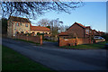
1
Ferry Lane, Winteringham, Lincolnshire
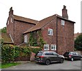
On 21 December 2007, North Lincolnshire Council granted planning approval to erect two 5-bedroom houses and part demolish and convert outbuildings to form associated garaging and vehicular access on land in Ferry Lane. Depicted is the former farm outbuilding converted to two garages for the new-build houses The Manor House and The Farmhouse, Nos. 12 & 10 Ferry Lane respectively.
Image: © Bernard Sharp
Taken: 14 Aug 2017
0.01 miles
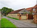
2
Ferry Lane, Winteringham, Lincolnshire
On 21 December 2007, North Lincolnshire Council granted planning approval to demolish and partly demolish existing barns and outbuildings and erect four dwelling houses and associated garaging and parking on land at Ferry Lane. Depicted is the barn, immediately north of No.4 Ferry Lane, that has been converted to a dwelling house known as The Stable.
Image: © Bernard Sharp
Taken: 14 Aug 2017
0.02 miles
3
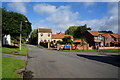
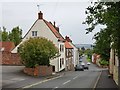
Ferry Lane Winteringham
A mixture of old and new properties
Image: © Martin Dawes
Taken: 2 May 2012
0.02 miles
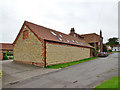
4

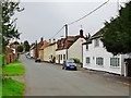
Ferry Lane, Winteringham, Lincolnshire
Ferry Lane Farmhouse, No.4 Ferry Lane, mid-18th century. Grade II Listed Building https://www.historicengland.org.uk/listing/the-list/list-entry/1117038
Image: © Bernard Sharp
Taken: 14 Aug 2017
0.03 miles
5
Ferry Lane, Winteringham, Lincolnshire
Ferry Lane Farmhouse, No.4 Ferry Lane, mid-18th century. Grade II Listed Building https://www.historicengland.org.uk/listing/the-list/list-entry/1117038
Image: © Bernard Sharp
Taken: 14 Aug 2017
0.03 miles
7
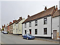
Low Burgage, Winteringham, Lincolnshire
Dwelling at No.15 Low Burgage.
Image: © Bernard Sharp
Taken: 14 Aug 2017
0.05 miles
8
Low Burgage, Winteringham, Lincolnshire
Looking south along Low Burgage from No.29.
Image: © Bernard Sharp
Taken: 14 Aug 2017
0.05 miles
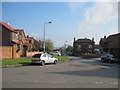
9
Low Burgage, Winteringham, Lincolnshire
Looking north along Low Burgage from Silver Street. The Yorkshire Wolds are visible on the horizon.
Image: © Bernard Sharp
Taken: 14 Aug 2017
0.05 miles