IMAGES TAKEN NEAR TO
Carlton, GOOLE, DN14 9NH
Introduction
This page details the photographs taken nearby to DN14 9NH by members of the Geograph project.
The Geograph project started in 2005 with the aim of publishing, organising and preserving representative images for every square kilometre of Great Britain, Ireland and the Isle of Man.

There are currently over 7.5m images from over14,400 individuals and you can help contribute to the project by visiting https://www.geograph.org.uk
Image Map
Images are licensed for reuse under creativecommons.org/licenses/by-sa/2.0
Notes
- Clicking on the map will re-center to the selected point.
- The higher the marker number, the further away the image location is from the centre of the postcode.
Image Listing (9 Images Found)
Images are licensed for reuse under creativecommons.org/licenses/by-sa/2.0
Image
Details
Distance
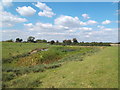
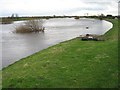
1
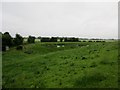
River Aire and Eskamhorn
The farm at Eskamhorn had a peacock on the top of a barn being very vocal
Image: © Martin Dawes
Taken: 15 Jun 2016
0.03 miles
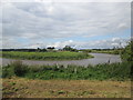
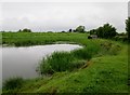
2
View towards Eskamhorn
Secluded spot with friendly occupants
Image: © Malcolm Campbell
Taken: 21 Jan 2008
0.08 miles
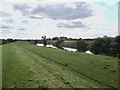
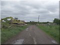
3
Field pond and River Aire flood bank
The farm at Eskamhorn over the river can just be seen
Image: © Martin Dawes
Taken: 15 Jun 2016
0.08 miles
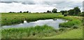
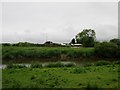
6
Field pond alongside River Aire flood bank
The flood bank is to the right I am on it, It shows how low the surrounding land is, the footpath to Field Lane and Rawcliffe goes left from the pond
Image: © Martin Dawes
Taken: 15 Jun 2016
0.15 miles