IMAGES TAKEN NEAR TO
Park Street, GOOLE, DN14 8DN
Introduction
This page details the photographs taken nearby to Park Street, DN14 8DN by members of the Geograph project.
The Geograph project started in 2005 with the aim of publishing, organising and preserving representative images for every square kilometre of Great Britain, Ireland and the Isle of Man.

There are currently over 7.5m images from over14,400 individuals and you can help contribute to the project by visiting https://www.geograph.org.uk
Image Map
Images are licensed for reuse under creativecommons.org/licenses/by-sa/2.0
Notes
- Clicking on the map will re-center to the selected point.
- The higher the marker number, the further away the image location is from the centre of the postcode.
Image Listing (20 Images Found)
Images are licensed for reuse under creativecommons.org/licenses/by-sa/2.0
Image
Details
Distance
2
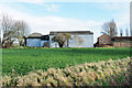
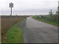
Barns at King's Causeway Farm
The farm and its barns are on the north side of King's Causeway, the A161, as it leaves Swinefleet heading east-south-east.
Image: © Trevor Littlewood
Taken: 16 Dec 2018
0.05 miles
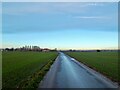
4
Shallow ditch between road and field
The road is the A161, King's Causeway, entering Swinefleet from the south-east. The buildings beyond the field and poplar trees are at King's Causeway Farm. The ditch, by the standards of this area of flat farmland, is indeed a very shallow one.
Image: © Trevor Littlewood
Taken: 7 Feb 2020
0.08 miles
5
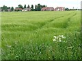
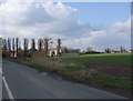
New houses on the edge of Swinefleet
Seen across a cereal field [barley?]on the west side of Reading Gate.
Image: © Christine Johnstone
Taken: 5 Jun 2013
0.10 miles
6
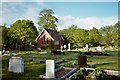
Swinefleet Cemetery
Chapel-of-rest in St Margaret's churchyard extension.
Image: © mfjordan
Taken: 7 May 2005
0.12 miles
10
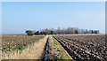
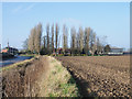
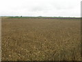
Ditch between two ploughed fields
The ditch, (drain on OS maps), is to the east of Reading Gate, (a road), just south of its junction with the A161, King's Causeway, south-east of Swinefleet. The A161 passes in front of the trees.
Image: © Trevor Littlewood
Taken: 7 Feb 2020
0.20 miles