IMAGES TAKEN NEAR TO
Towgarth Walk, GOOLE, DN14 7QU
Introduction
This page details the photographs taken nearby to Towgarth Walk, DN14 7QU by members of the Geograph project.
The Geograph project started in 2005 with the aim of publishing, organising and preserving representative images for every square kilometre of Great Britain, Ireland and the Isle of Man.

There are currently over 7.5m images from over14,400 individuals and you can help contribute to the project by visiting https://www.geograph.org.uk
Image Map
Images are licensed for reuse under creativecommons.org/licenses/by-sa/2.0
Notes
- Clicking on the map will re-center to the selected point.
- The higher the marker number, the further away the image location is from the centre of the postcode.
Image Listing (63 Images Found)
Images are licensed for reuse under creativecommons.org/licenses/by-sa/2.0
Image
Details
Distance
1
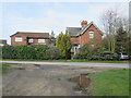
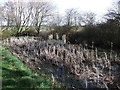
Dismantled railway line Eastrington
The Hull and Barnsley line closed 60 years ago, the house on the right over Carr Lane is a former railway property, probably a level crossing keeper's
Image: © Martin Dawes
Taken: 20 Mar 2019
0.04 miles
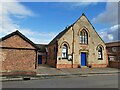
2
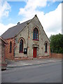
Methodist Church, Eastrington
Yellow and red brick Methodist church of 1893.
Image: © Gordon Hatton
Taken: 28 May 2009
0.07 miles
3
Eastrington Methodist Church
Former Wesleyan Church, built in 1893 at the eastern end of Queen Street, Eastrington.
Image: © Paul Glazzard
Taken: 19 Oct 2007
0.07 miles

5
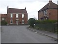
Road junction, Eastrington
Junction of Queen Street, Pinfold Street and Sandholme Road, looking towards the house called Lanegarth.
Image: © Paul Harrop
Taken: 3 Apr 2010
0.08 miles
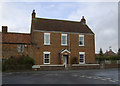
6
Duckingham Palace
A bit tired now...in need of a politician's expenses perhaps?
Image: © David Brown
Taken: 4 Mar 2019
0.08 miles
7
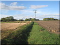
Field boundary near Eastrington
The trees in the distance mark the course of the former Hull and Barnsley Railway line.
Image: © Jonathan Thacker
Taken: 8 Oct 2013
0.08 miles
8
Junction of Pinfold street ,Queen Street and Sandholme Road
Image: © Glyn Drury
Taken: 9 Apr 2009
0.08 miles
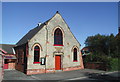
9
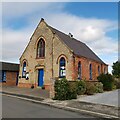
Eastrington Methodist church
Originally a Wesleyan Methodist congregation this building was erected in 1893. It looks as though the right hand side has had to be buttressed very soon after, or even during, construction.
Image: © Chris Morgan
Taken: 5 Oct 2020
0.09 miles
10
Eastrington Methodist church
Originally a Wesleyan Methodist congregation this building was erected in 1893. It looks as though the right hand side has had to be buttressed very soon after, or even during, construction.
Image: © Chris Morgan
Taken: 5 Oct 2020
0.09 miles