IMAGES TAKEN NEAR TO
St. Chads Square, DONCASTER, DN12 4TD
Introduction
This page details the photographs taken nearby to St. Chads Square, DN12 4TD by members of the Geograph project.
The Geograph project started in 2005 with the aim of publishing, organising and preserving representative images for every square kilometre of Great Britain, Ireland and the Isle of Man.

There are currently over 7.5m images from over14,400 individuals and you can help contribute to the project by visiting https://www.geograph.org.uk
Image Map (Loading...)


Getting Data...Please wait
Leaflet Map data © OpenStreetMap
Images are licensed for reuse under creativecommons.org/licenses/by-sa/2.0
Notes
- Clicking on the map will re-center to the selected point.
- The higher the marker number, the further away the image location is from the centre of the postcode.
Image Listing (26 Images Found)
Images are licensed for reuse under creativecommons.org/licenses/by-sa/2.0
Image
Details
Distance
1
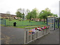
A roadside memorial on Doncaster Road, Denaby Main
Image: © Ian S
Taken: 19 May 2012
0.04 miles
2
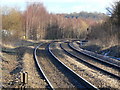
Railway to Doncaster
Looking east from Denaby Main level crossing. This apparently rural scene belies the fact that the growth of birch trees at the left hand side conceals the site of the extensive Denaby Main colliery.
Image: © Alan Murray-Rust
Taken: 10 Feb 2010
0.11 miles
3
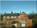
The Milestone Hotel
What's left of the hotel
Image: © stephen samson
Taken: 16 Nov 2008
0.12 miles
5

Somewhere over Denaby, 2 rainbows
Taken from Netto car park, Denaby Main. Looking toward the (now defunct) Earth Centre on a Saturday in February.
Image: © steve peet
Taken: 26 Feb 2011
0.17 miles
6
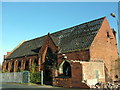
Hepworth Hall
Chapel was built in 1891. It was most recently used as a photographer's studio until a fire. Soon to be flats
Image: © stephen samson
Taken: 16 Nov 2008
0.18 miles
8
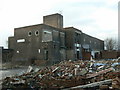
The last of Denaby Main
The former pit baths and canteen building is all that remains of the former colliery; it is now disused and appears to be ready for demolition.
Image: © Alan Murray-Rust
Taken: 10 Feb 2010
0.19 miles
9
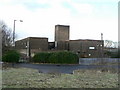
The last of Denaby Main
The former pit baths and canteen building is all that remains of the former colliery; it is now disused and appears to be ready for demolition.
Image: © Alan Murray-Rust
Taken: 10 Feb 2010
0.19 miles
10

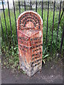
Old Milestone by old Doncaster Road, Denaby Main
Metal plate attached to stone post by the UC road (was B6023), in parish of Conisbrough (Doncaster District), Doncaster Road near railway crossing (road one way except for bicycles), on pavement, on North side of road. Brayshaw & Booth iron casting, erected by the County Council in the 19th century.
Inscription reads:-
: DONCASTER / 7 MILES / CONISBORO / 1½ MILES : : BRAMPTON BIERLOW & HOOTON / ROBERTS ROAD / SWINTON BRANCH / DENABY : : BARNSLEY / 15¼ MILES / WENTWORTH / 7½ MILES / SWINTON / 2¼ MILES / MEXBORO / 1¼ MILES :
Maker:-
: BRAYSHAW & BOOTH / MAKERS / LIVERSEDGE :
Grade II listed.
List Entry Number:1151532 https://historicengland.org.uk/listing/the-list/list-entry/1151532
Milestone Society National ID: YS_WWSW07.
Image: © Milestone Society
Taken: 14 Feb 2019
0.20 miles