IMAGES TAKEN NEAR TO
Black Horse Lane, NORTHALLERTON, DL6 3EP
Introduction
This page details the photographs taken nearby to Black Horse Lane, DL6 3EP by members of the Geograph project.
The Geograph project started in 2005 with the aim of publishing, organising and preserving representative images for every square kilometre of Great Britain, Ireland and the Isle of Man.

There are currently over 7.5m images from over14,400 individuals and you can help contribute to the project by visiting https://www.geograph.org.uk
Image Map
Images are licensed for reuse under creativecommons.org/licenses/by-sa/2.0
Notes
- Clicking on the map will re-center to the selected point.
- The higher the marker number, the further away the image location is from the centre of the postcode.
Image Listing (64 Images Found)
Images are licensed for reuse under creativecommons.org/licenses/by-sa/2.0
Image
Details
Distance
1
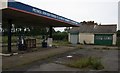
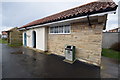
Disused Petrol Station, Swainby
According to the sign it was "forced to close by Swainby PC and National Park". PC would stand for Parish Council. So much for the local economy.
Image: © Mick Garratt
Taken: 19 Jun 2007
0.02 miles
2
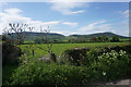
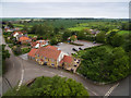
Field on the edge of Swainby
Looking south from Black Horse Lane towards Whorlton Moor.
Image: © Bill Boaden
Taken: 21 May 2015
0.03 miles
3
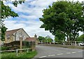
Blacksmiths and Swainby
The Blacksmiths Arms seems alternately known by the more trendy(?) 'Blacksmiths' on the sign.
Image: © Colin Grice
Taken: 2 Jun 2016
0.06 miles
4
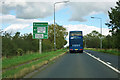
A172, Swainby
The loop road seems to be the course of a lane that the A172 replaced.
Image: © Robin Webster
Taken: 7 Oct 2011
0.07 miles
5
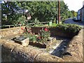
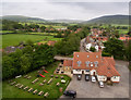
Swainby Pinfold
Most villages had at one time a pinfold or pound for stray cattle, sheep or pigs where they would stay until claimed by the owner on payment of a fine. Nowadays pinfolds are no longer used and a lot have been demolished. Swainby is a quiet village at the foot of the Cleveland Hills bisected by Scugdale Beck and its pinfold has been restored as a public space for the village.
From my blog: https://fhithich.wordpress.com/2015/09/16/swainby-pinfold/
Image: © Mick Garratt
Taken: 16 Sep 2015
0.07 miles
6
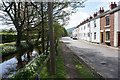
High Street, Swainby
The road runs each side of Scugdale Beck in the middle.
Image: © Bill Boaden
Taken: 21 May 2015
0.07 miles
7
Swainby, Maynards Bridge
There is a damaged benchmark cut into the south face of the northern parapet. Today only the horizontal datum line is obvious.
Image: © Mel Towler
Taken: 28 May 2022
0.08 miles
8
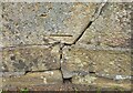
Swainby, Maynards Bridge
The damaged benchmark is cut into the south face of the northern parapet. Today only the horizontal datum line is obvious.
Image: © Mel Towler
Taken: 28 May 2022
0.08 miles
9
Blacksmiths Arms and view towards Hutton Rudby
The busy A172 at the end of their car park is a major route from the A19 to the more eastern side of Cleveland - and runs alongside the distinctive outline of The Cleveland Hills towards Roseberry Topping.
Presumably the original road ran directly in front of the building pretty much.
Image: © Colin Grice
Taken: 2 Jun 2016
0.08 miles