IMAGES TAKEN NEAR TO
Ruebury Lane, NORTHALLERTON, DL6 3AW
Introduction
This page details the photographs taken nearby to Ruebury Lane, DL6 3AW by members of the Geograph project.
The Geograph project started in 2005 with the aim of publishing, organising and preserving representative images for every square kilometre of Great Britain, Ireland and the Isle of Man.

There are currently over 7.5m images from over14,400 individuals and you can help contribute to the project by visiting https://www.geograph.org.uk
Image Map
Images are licensed for reuse under creativecommons.org/licenses/by-sa/2.0
Notes
- Clicking on the map will re-center to the selected point.
- The higher the marker number, the further away the image location is from the centre of the postcode.
Image Listing (54 Images Found)
Images are licensed for reuse under creativecommons.org/licenses/by-sa/2.0
Image
Details
Distance
1
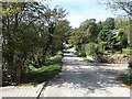
Ruebury Lane, Osmotherley
A loose surfaced residential street above the village with big views. The lane is used by the Cleveland Way.
Image: © Richard Webb
Taken: 1 Oct 2011
0.03 miles
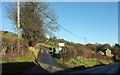
2
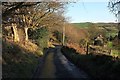
Ruebury Lane
The Cleveland Way and BOAT 10 111/012 follow this lane to Osmotherley.
Image: © Derek Harper
Taken: 27 Dec 2015
0.05 miles
3
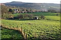
Towards Osmotherley
From the Way on Ruebury Lane, looking across the Cod Beck valley. On the horizon is Black Hambleton.
Image: © Derek Harper
Taken: 27 Dec 2015
0.06 miles
4
Shed in Field by Ruebury Lane, Osmotherley
Image: © Paul Buckingham
Taken: 17 Aug 2010
0.06 miles
5
Bridleway near Osmotherley
Bridleway 10 111/026 leaves Quarry Lane and starts a steady climb up Swinstye Hill.
Image: © Derek Harper
Taken: 27 Dec 2015
0.07 miles
6
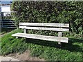
Bench, Quarry Lane
In memory of Alan Bosomworth. A bench on Quarry Lane, above Osmotherley.
Image: © Richard Webb
Taken: 1 Oct 2011
0.08 miles
7
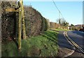
North End, Osmotherley
Seen from the junction with Ruebery Lane, used, as the sign indicates, by the Cleveland Way. Somewhere around here North End becomes Quarry Lane.
Image: © Derek Harper
Taken: 27 Dec 2015
0.08 miles
8
Osmotherley from the Cleveland Way
From Ruebury Lane (byway 10 111/012). The house with the long sloping roof left of centre is listed http://www.historicengland.org.uk/listing/the-list/list-entry/1315150 .
Image: © Derek Harper
Taken: 27 Dec 2015
0.09 miles
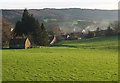
9
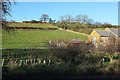
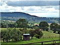
Fields near Osmotherley
From the same point as Image], looking in the opposite direction. The farm is Brackenrigg. The combination of hedge and fence crossing the image above it marks the course of bridleway 10 111/026. Behind is Summer Game Hill, where woodland surround Lady's Chapel.
Image: © Derek Harper
Taken: 27 Dec 2015
0.10 miles
10
Pinfold, Osmotherley
A pinfold was used as a pound for stray cattle, sheep or pigs where they would stay until claimed by the owner on payment of a fine. Nearly all villages once had a pinfold, but well-preserved surviving examples are now rare. The structure was restored in 2011.
The Osmotherley pound may date from the C18th and is Grade II Listed (List Entry Number: 1392090) https://historicengland.org.uk/listing/the-list/list-entry/1392090
Image: © Andrew Curtis
Taken: 14 May 2019
0.10 miles