IMAGES TAKEN NEAR TO
Melbourne Place, BISHOP AUCKLAND, DL13 3EQ
Introduction
This page details the photographs taken nearby to Melbourne Place, DL13 3EQ by members of the Geograph project.
The Geograph project started in 2005 with the aim of publishing, organising and preserving representative images for every square kilometre of Great Britain, Ireland and the Isle of Man.

There are currently over 7.5m images from over14,400 individuals and you can help contribute to the project by visiting https://www.geograph.org.uk
Image Map
Images are licensed for reuse under creativecommons.org/licenses/by-sa/2.0
Notes
- Clicking on the map will re-center to the selected point.
- The higher the marker number, the further away the image location is from the centre of the postcode.
Image Listing (124 Images Found)
Images are licensed for reuse under creativecommons.org/licenses/by-sa/2.0
Image
Details
Distance
1
Terrace off Silver Street, Wolsingham
Taken from the west rise of the Waskerley Bridge.
Image: © Andrew Curtis
Taken: 2 Sep 2011
0.03 miles
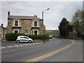
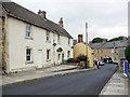
2
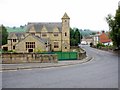
East End, Wolsingham
Photo taken from the west end of the bridge over the Waskerley Beck. East End is the main road through Weardale (A689). The grand building on the left was formerly the Parish Hall and associated buildings recently converted for residential use.
Image: © Andrew Curtis
Taken: 2 Sep 2011
0.03 miles
3
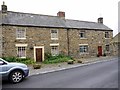
Numbers 6 & 8 Meadhope Street, Wolsingham
Meadhope Street is one of the oldest in Wolsingham. Both of these joined cottages have dates above their doors.
Number 8 (on the left) is dated 1740 and retains its original oak beams in the front room.
National Heritage List for England Entry Number: 1276771 https://www.historicengland.org.uk/listing/the-list/list-entry/1276771
Number 6 (on the right) is dated 1720.
Image: © Andrew Curtis
Taken: 2 Sep 2011
0.05 miles
4
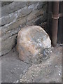
Old Bridge Marker on the A689 in Wolsingham
County Bridge Marker on the north side of the A689 west of Waskerley Bridge, Waskerley Beck. Wolsingham parish. Inscribed C. The stone marks the extent of roadway adjoining the bridge that Durham County was obliged to maintain.
Milestone Society National ID: DU_WOL01br
Image: © Mike Rayner
Taken: 17 Feb 2019
0.05 miles
6
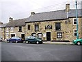
Black Lion, Meadhope Street
The website for the pub states: 'The Black Lion Inn is the oldest pub in Weardale. Not obvious when you first come into the village, The Lion's many fans walk away from the market place up the hill and turn right into Meadhope Street' http://blacklionwolsingham.blogspot.com/
Image: © Andrew Curtis
Taken: 2 Sep 2011
0.05 miles
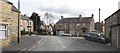
8
East End
The main road out of the town towards Bishop Auckland and Durham.
Image: © Alan Murray-Rust
Taken: 10 Nov 2009
0.06 miles
9
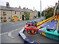
East End, Wolsingham
Funfair laid out in spaces around the village as part of the Wolsingham Show held on the first weekend of September.
Image: © Andrew Curtis
Taken: 2 Sep 2011
0.07 miles
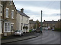
10
North end of Meadhope Street, Wolsingham
Looking towards its junction with Silver Street.
Image: © Andrew Curtis
Taken: 2 Sep 2011
0.07 miles