IMAGES TAKEN NEAR TO
Angate Square, BISHOP AUCKLAND, DL13 3EP
Introduction
This page details the photographs taken nearby to Angate Square, DL13 3EP by members of the Geograph project.
The Geograph project started in 2005 with the aim of publishing, organising and preserving representative images for every square kilometre of Great Britain, Ireland and the Isle of Man.

There are currently over 7.5m images from over14,400 individuals and you can help contribute to the project by visiting https://www.geograph.org.uk
Image Map
Images are licensed for reuse under creativecommons.org/licenses/by-sa/2.0
Notes
- Clicking on the map will re-center to the selected point.
- The higher the marker number, the further away the image location is from the centre of the postcode.
Image Listing (128 Images Found)
Images are licensed for reuse under creativecommons.org/licenses/by-sa/2.0
Image
Details
Distance
1
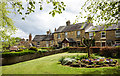
Flower bed and lawn at Angate Square
Angate Square on the eastern side of Angate Street, the B6296, in Wolsingham.
Image: © Trevor Littlewood
Taken: 1 May 2020
0.00 miles
2
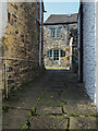
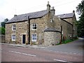
Cottage at end of stone-paved lane
The paved lane leaves the northern end of Meadhope Street in Wolsingham.
Image: © Trevor Littlewood
Taken: 27 Mar 2020
0.01 miles
3
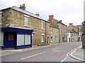
Angate Street, Wolsingham
The three-storey house with the red brick chimney is number 34, 'Rivendell', which dates from the late C18th and is grade II listed (List Entry Number: 1276975) https://historicengland.org.uk/listing/the-list/list-entry/1276975
Image: © Andrew Curtis
Taken: 2 Sep 2011
0.02 miles
4
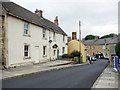
North end of Meadhope Street, Wolsingham
Looking towards its junction with Silver Street.
Image: © Andrew Curtis
Taken: 2 Sep 2011
0.02 miles
5
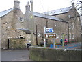
Converted building of St Anne's Convent, Angate Street
St Anne's Convent and girls' school was established in 1892. It was sold for development in 2004. Several of the original buildings were converted for private houses and land to the rear has been developed with new houses and apartments. The road by the side leads to the Demesne Mill long-stay car park and picnic area Image
There is a photo from the same location here Image
Image: © Andrew Curtis
Taken: 2 Sep 2011
0.03 miles
6
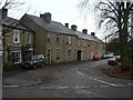
Co-operative Terrace
Attractive stone built terrace at Angate Green.
Image: © Alan Murray-Rust
Taken: 10 Nov 2009
0.03 miles
7
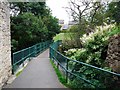
Footbridge over Waskerley Beck
The bridge provides a pedestrian route to the town centre from Upper Town.
Image: © Andrew Curtis
Taken: 2 Sep 2011
0.04 miles
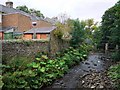
8
Angate Street entrance to picnic area Wolsingham
Seen from the road bridge over Waskerley Beck in this County Durham town
Image: © Peter Robinson
Taken: 7 Feb 2010
0.04 miles
10
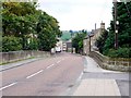
Waskrow Bridge, Wolsingham
Bridge over Waskerley Beck on entering the town of Wolsingham on the road from Tow Law. The earliest large scale OS map shows that the beck was also called the Wascrow.
Image: © Andrew Curtis
Taken: 2 Sep 2011
0.04 miles