IMAGES TAKEN NEAR TO
Front Street, BISHOP AUCKLAND, DL13 2BA
Introduction
This page details the photographs taken nearby to Front Street, DL13 2BA by members of the Geograph project.
The Geograph project started in 2005 with the aim of publishing, organising and preserving representative images for every square kilometre of Great Britain, Ireland and the Isle of Man.

There are currently over 7.5m images from over14,400 individuals and you can help contribute to the project by visiting https://www.geograph.org.uk
Image Map
Images are licensed for reuse under creativecommons.org/licenses/by-sa/2.0
Notes
- Clicking on the map will re-center to the selected point.
- The higher the marker number, the further away the image location is from the centre of the postcode.
Image Listing (94 Images Found)
Images are licensed for reuse under creativecommons.org/licenses/by-sa/2.0
Image
Details
Distance
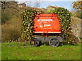
1
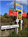
Signs below Hylton Terrace, Rookhope
Disguised among the 'For Sale' signs is one telling cyclists that the alternative C2C route which ascends Boltslaw Incline is closed because of grouse shooting on the moors above.
Image: © Andrew Curtis
Taken: 17 Oct 2014
0.01 miles
2
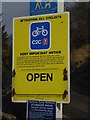
Attention all cyclists!
Notice at the beginning of the notorious Boltslaw Incline which carries the world-famous C2C cycle route. As one of the conditions for establishing the route, the owners of Stanhope Common insisted that cyclists should not use this part of the route when grouse shooting is in progress. It is not clear how cyclists are expected to disturb the birds any more than the walkers who cannot be banned because the incline is a public footpath. Beneath this notice is another specifying the dates in the year when shooting will take place. There is a roundabout
on-road route to be taken at these times.
Image: © Oliver Dixon
Taken: 22 Feb 2019
0.01 miles
3
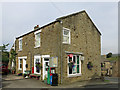
Rookhope Post Office
Image: © Mike Quinn
Taken: 26 Jun 2020
0.02 miles
4
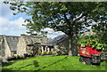
Grassed area with mine tub
The small lawn is at the centre of the village of Rookhope which has a history of lead mining, and so the mine tub on display.
The building immediately beyond the grass is a public convenience. The two other buildings are part of a cluster around a yard; one is dilapidated, the other is part of an extensive renovation which has been ongoing for some years.
Image: © Trevor Littlewood
Taken: 28 Aug 2023
0.02 miles

7
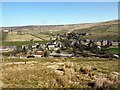
Rookhope village
The lead mining community of Rookhope took its name from the valley and grew up from the originally separate settlements of Boltsburn and Stotsfield. The history of mining in this area is given in http://www.pastperfect.org.uk/sites/oldrookhope/index.html
The poet WH Auden was inspired by the decaying industrial heritage in this area. In a letter to Lord Byron (1937) he states: "Tramlines and slagheaps, pieces of machinery. That was, and still is, my ideal scenery."
Image: © Andrew Curtis
Taken: 3 Apr 2009
0.02 miles
8
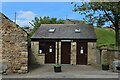
Public Convenience, Rookhope
Looks a relatively new construction, and handy for Weardale Way walkers, as the local pub was closed.
Image: © Chris Heaton
Taken: 18 May 2022
0.02 miles
9
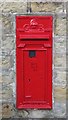
George V postbox, Rookhope Post Office
Part of the post office (but not this postbox) is shown in Image It looks as though the box, DL13 97, has recently had some tlc, and is waiting for replacement of the plate showing the collection times. See also Image
Image: © Mike Quinn
Taken: 29 Nov 2019
0.02 miles
10
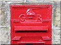
George V postbox, Rookhope Post Office (detail)
See Image This small wallbox has had the aperture modified to a width of 8 inches; the original aperture was enlarged and a new casting fitted in situ. A similar postbox that has not been so modified is shown in Image (photographed by JThomas).
Image: © Mike Quinn
Taken: 29 Nov 2019
0.02 miles