IMAGES TAKEN NEAR TO
Brotherlee, Westgate, BISHOP AUCKLAND, DL13 1SR
Introduction
This page details the photographs taken nearby to DL13 1SR by members of the Geograph project.
The Geograph project started in 2005 with the aim of publishing, organising and preserving representative images for every square kilometre of Great Britain, Ireland and the Isle of Man.

There are currently over 7.5m images from over14,400 individuals and you can help contribute to the project by visiting https://www.geograph.org.uk
Image Map
Images are licensed for reuse under creativecommons.org/licenses/by-sa/2.0
Notes
- Clicking on the map will re-center to the selected point.
- The higher the marker number, the further away the image location is from the centre of the postcode.
Image Listing (28 Images Found)
Images are licensed for reuse under creativecommons.org/licenses/by-sa/2.0
Image
Details
Distance
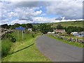
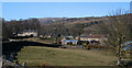
3
Ford a Brotherlee
The public footpath passes through the ford in the garden of this house at Brotherlee.
Image: © John Walton
Taken: 25 Mar 2018
0.04 miles
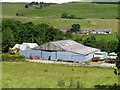
4
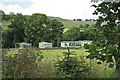
Caravan park, Brotherlee
Caravans painted green to blend in with the scenery at Brotherlee
Image: © Helen Wilkinson
Taken: 17 Jul 2007
0.05 miles
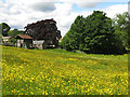
7
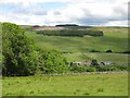
Upper Weardale around Brotherlee
Looking north across the valley towards Heights Quarry in Image
Image: © Mike Quinn
Taken: 21 Jun 2019
0.08 miles
8
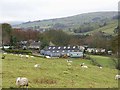
Brotherlee
Hamlet on the south side of Weardale. To the right can be seen one of several caravan parks which are sited, rather surprisingly, along the length of Weardale.
Image: © Oliver Dixon
Taken: 5 Nov 2008
0.08 miles
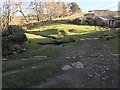
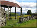
10
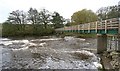
Brotherlee footbridge
This is an extremely well-built bridge for a mere footpath, with a very long main span which makes it quite wobbly if you have a wide gait (or just like making bridges sway...). At low levels, the river occupies only a part of the north side of this span, but at a level when you might think of canoeing on the Upper Wear, the water flows under the full width of the bridge. The flow slides down over rock slabs leading to a wave, which shouldn't give the paddler much trouble, and is probably playable at this sort of level, though may not be very retentive. There's excellent service from big eddies on both sides.
Image: © Andy Waddington
Taken: 8 Nov 2009
0.12 miles