IMAGES TAKEN NEAR TO
Marrick, RICHMOND, DL11 7LG
Introduction
This page details the photographs taken nearby to DL11 7LG by members of the Geograph project.
The Geograph project started in 2005 with the aim of publishing, organising and preserving representative images for every square kilometre of Great Britain, Ireland and the Isle of Man.

There are currently over 7.5m images from over14,400 individuals and you can help contribute to the project by visiting https://www.geograph.org.uk
Image Map
Images are licensed for reuse under creativecommons.org/licenses/by-sa/2.0
Notes
- Clicking on the map will re-center to the selected point.
- The higher the marker number, the further away the image location is from the centre of the postcode.
Image Listing (10 Images Found)
Images are licensed for reuse under creativecommons.org/licenses/by-sa/2.0
Image
Details
Distance
1
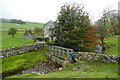
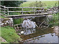
Footbridge at Ellers
The public footpath from Marrick to the Marske road passes over a stream by this footbridge at Ellers. Immediately upstream, the stream is called Ellers Beck, but some distance downstream (perhaps immediately below the bridge) it is called North Gill. Quite a way upstream, it started life as Dales Beck, and before joining the River Swale as a left bank tributary, it has become Oxque Gill. Four different names in only four kilometres !
Image: © Andy Waddington
Taken: 24 Oct 2020
0.01 miles
2
Footbridge at Ellers
Much used bridge over Ellers Beck on the Coast to Coast route. The beck here marks the boundary between Marske and Marrick parishes.
Image: © Gordon Hatton
Taken: 3 Aug 2022
0.01 miles
3
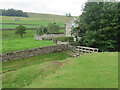
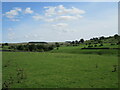
Ellers Beck
Looking east alongside Ellers Beck near Marrick.
Image: © T Eyre
Taken: 21 Jul 2010
0.03 miles
4
Wooden Footbridge over Ellers Beck
Ellers Beck uprises as Stelling Spring in NZ0600 before becoming Dales Beck in NZ0700. It becomes Ellers Beck when Wild Sike joins it at SE082995. It then becomes North Gill in SE0999, and finally Oxque Beck in SE098989 before joining the River Swale. It is approximately 3 miles long.
Image: © Matthew Hatton
Taken: 19 Sep 2009
0.03 miles
5
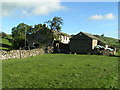
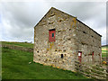
Ellers
Remotely situated farm on the Coast-to-Coast long-distance path between Marrick and Marske.
Image: © Dave Dunford
Taken: 23 Oct 2006
0.08 miles
8
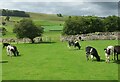
Coast to Coast path near Hollin Farm
The young cattle here seem quite unconcerned about a passing walker, but then many pass here every day through the summer as they trek from coast to coast. For such a heavily used route, there's relatively little wear on the grass surface.
Image: © Gordon Hatton
Taken: 3 Aug 2022
0.19 miles
9
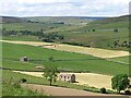
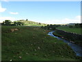
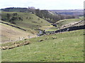
Green and yellow fields near Nun Cote
A view from Shaw Bank across the shallow valley of Ellers Beck where green fields contrast with the more yellow shades of those recently cut for winter feed. In the distance and left of centre are the ruins of Marrick lead smelting mill.
Image: © Gordon Hatton
Taken: 21 Jun 2022
0.22 miles