IMAGES TAKEN NEAR TO
Harkerside, RICHMOND, DL11 6JD
Introduction
This page details the photographs taken nearby to Harkerside, DL11 6JD by members of the Geograph project.
The Geograph project started in 2005 with the aim of publishing, organising and preserving representative images for every square kilometre of Great Britain, Ireland and the Isle of Man.

There are currently over 7.5m images from over14,400 individuals and you can help contribute to the project by visiting https://www.geograph.org.uk
Image Map
Images are licensed for reuse under creativecommons.org/licenses/by-sa/2.0
Notes
- Clicking on the map will re-center to the selected point.
- The higher the marker number, the further away the image location is from the centre of the postcode.
Image Listing (46 Images Found)
Images are licensed for reuse under creativecommons.org/licenses/by-sa/2.0
Image
Details
Distance
1
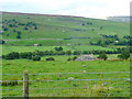
View over Ivy House
Looking north over Swaledale towards Riddings.
Image: © Jonathan Billinger
Taken: 7 Sep 2010
0.05 miles
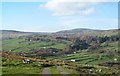
2
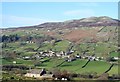
View from above Ivy House
Ivy House sits below on the hillside, whilst on the other side of the dale is the village of Healaugh with Calver Hill beyond. With the exception of Grinton, the other major settlements along Swaledale all sit on the 'sunny' side of the dale facing south. In several villages houses on the south side of the road have their backs to the road and frontage towards the sun.
Image: © Gordon Hatton
Taken: 15 Nov 2018
0.06 miles
3
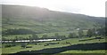
Harkerside Field Systems
The view across the Swale towards Harkerside, where in the low afternoon light it is possible to pick out the lines and humps of ancient fields and tracks, most likely dating from the iron age and probably constructed by the local Brigantes tribe.
Image: © Gordon Hatton
Taken: 26 Oct 2008
0.09 miles
4
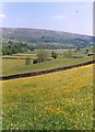
Hay meadow at Harkerside
Flower filled meadows just above the River Swale near Reeth.
Image: © Gordon Hatton
Taken: Unknown
0.10 miles
5
Track to Ivy House
Farm track and public footpath dropping down the hillside towards Ivy House. The view is across the dale towards the wooded gill that contains Barney Beck.
Image: © Gordon Hatton
Taken: 15 Nov 2018
0.12 miles
6
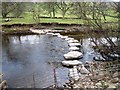
Stepping Stones across the River Swale
This photograph shows a view of a set of stepping stones across the River Swale near the village of Healaugh. The picture was taken looking in a south-easterly direction towards Ivy House - which can just be seen through the trees near the top of the image.
Image: © Philip Barker
Taken: 18 Apr 2010
0.14 miles
7
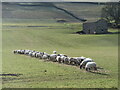
Winter feed
A line of sheep tucking into hay which has been spread down this field next to the Swale.
Image: © Gordon Hatton
Taken: 11 Feb 2022
0.14 miles
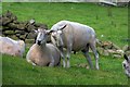
9
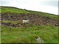
Sheep above Swale Hall Lane
The local Swaledale breed.
Image: © Stephen Craven
Taken: 28 May 2023
0.16 miles
10
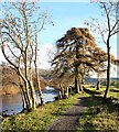
Riverside path downstream from the stepping stones
The bridleway here has been surfaced to provide a better route for cyclists using the 'Swale Trail', which officially opened in April 2018. The larch tree is unusual, but adds variety to the usual alder and ash along the path.
Image: © Gordon Hatton
Taken: 10 Dec 2018
0.16 miles