IMAGES TAKEN NEAR TO
The Grange, STANLEY, DH9 9UT
Introduction
This page details the photographs taken nearby to The Grange, DH9 9UT by members of the Geograph project.
The Geograph project started in 2005 with the aim of publishing, organising and preserving representative images for every square kilometre of Great Britain, Ireland and the Isle of Man.

There are currently over 7.5m images from over14,400 individuals and you can help contribute to the project by visiting https://www.geograph.org.uk
Image Map
Images are licensed for reuse under creativecommons.org/licenses/by-sa/2.0
Notes
- Clicking on the map will re-center to the selected point.
- The higher the marker number, the further away the image location is from the centre of the postcode.
Image Listing (17 Images Found)
Images are licensed for reuse under creativecommons.org/licenses/by-sa/2.0
Image
Details
Distance
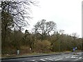
1
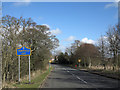
Minor road entering Tanfield Lea
The road enters Tanfield Lea from the south-west passing the blue and yellow road sign which is in a style introduced in County Durham some years ago.
Image: © Trevor Littlewood
Taken: 7 Mar 2014
0.15 miles
2
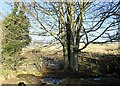
Path crossing the Houghwell Burn
The field path from Harperley Lane goes over the small stream here.
Image: © Robert Graham
Taken: 24 Jan 2022
0.19 miles
3
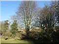
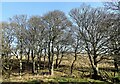
Trees along the burn
These trees form a thin strip of woodland along the Houghwell Burn running down from White-le-Head to Tanfield Lea.
Image: © Robert Graham
Taken: 24 Jan 2022
0.19 miles
4

Bus at Tanfield Lea
This is the Stanley Travel service No 713 on its way from Stanley to Tantobie. The service follows a circular route through the local villages taking in Tanfield Lea, Tantobie, Flint Hill, Dipton and Annfield Plain among others.
Image: © Robert Graham
Taken: 6 Mar 2023
0.19 miles
5
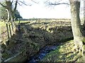
Ford on the Houghwell Burn
The path from Harperley Lane to Tanfield Lea crosses the stream here.
Image: © Robert Graham
Taken: 24 Jan 2022
0.20 miles
6
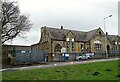
Tanfield Lea Primary School
This was originally built in 1893 as The Tanfield Board School.
Image: © Robert Graham
Taken: 6 Mar 2023
0.20 miles
7
Trees along the Houghwell Burn
Beside the path running to Tanfield Lea. The stream is in the dip between the trees.
Image: © Robert Graham
Taken: 24 Jan 2022
0.21 miles
8
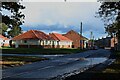
New Front Street, Tanfield Lea
A street in the village of Tanfield Lea.
Image: © Graham Robson
Taken: 28 Oct 2018
0.21 miles
9
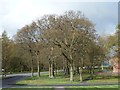
Stand of trees, Tanfield Lea
A detached corner of woodland, at the western end of New Front Street.
Image: © Christine Johnstone
Taken: 13 Apr 2012
0.21 miles
10
Tanfield Lea Park
This is really a small wood, and is shown as Noble's Wood on old maps. It flanks the main road through the village, the B6173.
Image: © Robert Graham
Taken: 6 Mar 2023
0.22 miles