IMAGES TAKEN NEAR TO
Tanfield Lea, STANLEY, DH9 9NT
Introduction
This page details the photographs taken nearby to DH9 9NT by members of the Geograph project.
The Geograph project started in 2005 with the aim of publishing, organising and preserving representative images for every square kilometre of Great Britain, Ireland and the Isle of Man.

There are currently over 7.5m images from over14,400 individuals and you can help contribute to the project by visiting https://www.geograph.org.uk
Image Map
Images are licensed for reuse under creativecommons.org/licenses/by-sa/2.0
Notes
- Clicking on the map will re-center to the selected point.
- The higher the marker number, the further away the image location is from the centre of the postcode.
Image Listing (28 Images Found)
Images are licensed for reuse under creativecommons.org/licenses/by-sa/2.0
Image
Details
Distance
1
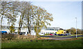
Industrial unit at Tanfield Lea
The factory is operated by KP Snacks and is on the Tanfield Lea Industrial Estate North.
Image: © Trevor Littlewood
Taken: 25 Nov 2021
0.06 miles
2
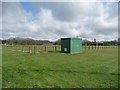
Sports ground, New Front Street, Tanfield Lea
Not sure what is going on inside the green box, possibly electricity supply.
Image: © Christine Johnstone
Taken: 13 Apr 2012
0.08 miles
3
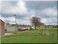
Bungalows on Northleigh, Tanfield Lea
Seen from New Front Street.
Image: © Christine Johnstone
Taken: 13 Apr 2012
0.12 miles
4

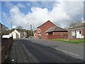
Village main street
New Front Street in Tanfield Lea. I think that the building on the left was the Post Office originally, doesn't seem to be now.
Image: © Robert Graham
Taken: 6 Mar 2023
0.12 miles
5
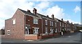
Terraced houses, Tanfield Lea
On the south side of New Front Street.
Image: © Christine Johnstone
Taken: 13 Apr 2012
0.12 miles
6
Tanfield Lea Post Office
Looking west along New Front Street.
Image: © Christine Johnstone
Taken: 13 Apr 2012
0.14 miles
7
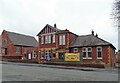
Tanfield Lea Community Centre
Built in 1925 as the Memorial Welfare Hall. Memorial to WWI of course, and there is a list inside of those who served and of the fallen.
Image: © Robert Graham
Taken: 6 Mar 2023
0.15 miles
8

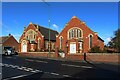
Former Methodist Church in Tanfield Lea
These fine buildings were opened in 1913. They consisted of a church, and attached schoolroom and church hall. Not sure what they are being used for now that the church has closed. The third building in this row is the Community Centre.
Image: © Robert Graham
Taken: 6 Mar 2023
0.16 miles
9
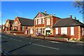
Tanfield Lea Community Centre
A community centre is found in the centre of Tanfield Lea.
Image: © Graham Robson
Taken: 28 Oct 2018
0.16 miles
10
Former Methodist chapel and hall, Tanfield Lea
The large Methodist chapel and adjoining hall share quite a resemblence in scale and appearance. Both are closed.
Image: © Graham Robson
Taken: 28 Oct 2018
0.16 miles