IMAGES TAKEN NEAR TO
Tanfield Lea, STANLEY, DH9 9LX
Introduction
This page details the photographs taken nearby to DH9 9LX by members of the Geograph project.
The Geograph project started in 2005 with the aim of publishing, organising and preserving representative images for every square kilometre of Great Britain, Ireland and the Isle of Man.

There are currently over 7.5m images from over14,400 individuals and you can help contribute to the project by visiting https://www.geograph.org.uk
Image Map
Images are licensed for reuse under creativecommons.org/licenses/by-sa/2.0
Notes
- Clicking on the map will re-center to the selected point.
- The higher the marker number, the further away the image location is from the centre of the postcode.
Image Listing (38 Images Found)
Images are licensed for reuse under creativecommons.org/licenses/by-sa/2.0
Image
Details
Distance
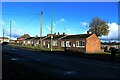
1
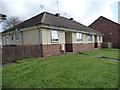
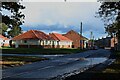
Parkside Cottages
Semi-detached bungalows on New Front Street, Tanfield Lea.
Image: © Christine Johnstone
Taken: 13 Apr 2012
0.01 miles
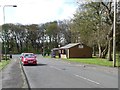
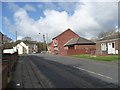
2
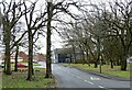
New Front Street, Tanfield Lea
A bit of a misnomer, as this was the original Front Street in the 19th century. It seems to have been renamed in the post war period after a re-alinement of the roads. The village shops etc were all along here, and still are.
Image: © Robert Graham
Taken: 6 Mar 2023
0.02 miles
3
Paths across open space, Tanfield Lea
Between New Front Street and the B6173.
Image: © Christine Johnstone
Taken: 13 Apr 2012
0.02 miles
4
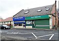
Village shops in Tanfield Lea
Local shops on new Front Street, the village centre. Tanfield Lea is a former mining village, mostly dating from the 19th century.
Image: © Robert Graham
Taken: 6 Mar 2023
0.03 miles
5
Bungalows, New Front Street, Tanfield Lea
A short row of small bungalows on New Front Street in Tanfield Lea.
Image: © Graham Robson
Taken: 28 Oct 2018
0.03 miles
6
Barber's shop, Tanfield Lea
Known as the Green Hut.
Image: © Christine Johnstone
Taken: 13 Apr 2012
0.03 miles
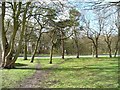
7
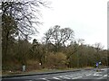
Tanfield Lea Park
This is really a small wood, and is shown as Noble's Wood on old maps. It flanks the main road through the village, the B6173.
Image: © Robert Graham
Taken: 6 Mar 2023
0.03 miles
8
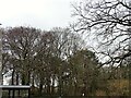
Tanfield Lea Park Rookery
This is in reality a small wood, beside the B6173 which runs through the village. The most notable thing about this picture is something which is missing, and that is the Rooks nests. For as many years as I can remember, and that goes back to the 1950's, there was a large rookery in these trees. The birds would have been already back at their nests at this time in the early spring, but there are none now. Also, the old nests from previous years would have been in the tree tops, which means that the rookery must have been deserted from a year or so before this year. Rook numbers have been falling locally, and this is proof.
Image: © Robert Graham
Taken: 6 Mar 2023
0.04 miles
9
New Front Street, Tanfield Lea
A street in the village of Tanfield Lea.
Image: © Graham Robson
Taken: 28 Oct 2018
0.04 miles
10
Tanfield Lea Post Office
Looking west along New Front Street.
Image: © Christine Johnstone
Taken: 13 Apr 2012
0.04 miles