IMAGES TAKEN NEAR TO
Murray Terrace, STANLEY, DH9 9HB
Introduction
This page details the photographs taken nearby to Murray Terrace, DH9 9HB by members of the Geograph project.
The Geograph project started in 2005 with the aim of publishing, organising and preserving representative images for every square kilometre of Great Britain, Ireland and the Isle of Man.

There are currently over 7.5m images from over14,400 individuals and you can help contribute to the project by visiting https://www.geograph.org.uk
Image Map
Images are licensed for reuse under creativecommons.org/licenses/by-sa/2.0
Notes
- Clicking on the map will re-center to the selected point.
- The higher the marker number, the further away the image location is from the centre of the postcode.
Image Listing (30 Images Found)
Images are licensed for reuse under creativecommons.org/licenses/by-sa/2.0
Image
Details
Distance
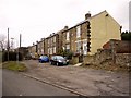
1

Front Street, Dipton
The very busy A692.
Image: © Oliver Dixon
Taken: 27 Jan 2022
0.03 miles
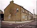
2

Former Red Lion pub
A striking Edwardian structure at the junction of Cooperative Terrace with Front Street.
Image: © Oliver Dixon
Taken: 27 Jan 2022
0.09 miles
3

Former Red Lion pub, Dipton
On the corner of Front Street and Co-operative Terrace, the disused pub was for a time a shrine to Sapper Daryn Roy killed in a roadside bomb in Afghanistan on May 3rd 2010. A sign in the boarded up windows reads, "Daryn Roy. Dipton hero"
http://www.chroniclelive.co.uk/north-east-news/evening-chronicle-news/2010/05/19/dipton-pay-tribute-to-tragic-soldier-daryn-roy-72703-26475933/
Image: © Andrew Curtis
Taken: 7 Jan 2011
0.09 miles
4

Co-operative Terrace, Dipton
Showing the Post Office and Club on the south side of the street, opposite the shops.
Image: © Andrew Curtis
Taken: 7 Jan 2011
0.10 miles
5
Front Street, Dipton from junction with Co-operative Terrace
London House is on the corner, opposite the former Red Lion pub.
Image: © Andrew Curtis
Taken: 7 Jan 2011
0.10 miles
6
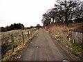
The track of Catchwell Road, Dipton
The track is on the line of the old Pontop Pike waggonway. The waggonways were laid out in this area as early as 1728. Horses were used to pull chaldron waggons along wooden rails of a usual gauge of 4 feet, transporting coal from the many pits around Pontop Pike towards staithes on the nearby rivers. A chaldron is a unit of dry measure which was 36 bushels for coal. The waggonways consisted of two tracks laid side by side, the main way and the bye way. The main way carried the full wagon down gradient, and then on the bye way, the horse pulled the empty wagon up gradient.
There is a detailed essay here http://www.pontvalley.net/cms/index.php?module=pagemaster&PAGE_user_op=view_page&PAGE_id=26
Image: © Andrew Curtis
Taken: 7 Jan 2011
0.11 miles
7

Collierley Primary School, Dipton
The village school first opened in 1878 as Colliery Board School. In those days, Dipton referred to the northern end of the village only, and the southern part was called Collierley.
Image: © Robert Graham
Taken: 11 Apr 2022
0.12 miles
8
Delight Row & Wordsworth Gardens, Dipton
Image: © Andrew Curtis
Taken: 7 Jan 2011
0.12 miles
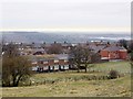
9
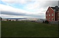
Open space on Front Street, Dipton
This open area in the centre of the village is used as a playing field. The gap in the built up area gives great views to the NW across the Derwent Valley. The building on the right is Dipton Manor Care Home, which was built recently on the site of the old Bute Arms pub.
Image: © Robert Graham
Taken: 20 Mar 2019
0.13 miles