
IMAGES TAKEN NEAR TO
Lily Gardens, STANLEY, DH9 9BH
Introduction
This page details the photographs taken nearby to Lily Gardens, DH9 9BH by members of the Geograph project.
The Geograph project started in 2005 with the aim of publishing, organising and preserving representative images for every square kilometre of Great Britain, Ireland and the Isle of Man.

There are currently over 7.5m images from over14,400 individuals and you can help contribute to the project by visiting https://www.geograph.org.uk
Image Map
Images are licensed for reuse under creativecommons.org/licenses/by-sa/2.0
Notes
- Clicking on the map will re-center to the selected point.
- The higher the marker number, the further away the image location is from the centre of the postcode.
Image Listing (14 Images Found)
Images are licensed for reuse under creativecommons.org/licenses/by-sa/2.0
Image
Details
Distance
1
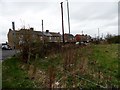
Old boundary wall
This old wall is on North Road, Dipton, next to the junction with Bushblades Lane. It probably formed the boundary wall of Bushblades Township, at the edge of Lanchester Common. After the 1773 Enclosures Act, North road was set out and the wall would have formed part of the boundary of this road. The street across the road is Poplar Grove.
Image: © Robert Graham
Taken: 9 Apr 2014
0.05 miles
2

Footpath below North Road, Flint Hill
It seems very possible that this footpath follows the track of an old mineral railway.
Image: © Oliver Dixon
Taken: 28 Feb 2014
0.06 miles
3

Waste ground with dock plants
Dock plants gone to seed dominate the ground visually in this small enclosure between North Road and Bushblades Lane in Flint Hill.
Image: © Trevor Littlewood
Taken: 2 Sep 2023
0.07 miles
4
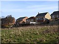
An outbreak of decking at Lily Gardens, Flint Hill
Image: © Oliver Dixon
Taken: 28 Feb 2014
0.08 miles
5

Footpath from Flint Hill to Dipton
It seems very possible that this footpath follows the track of an old mineral railway.
Image: © Oliver Dixon
Taken: 28 Feb 2014
0.14 miles
6
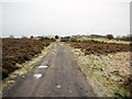
Track east of Dipton
The small patch of heather moorland is the site of Catch Pit, another 1740s coal mine. The aerials of Pontop Pike are visible in the distance on the right, beyond the allotment gardens.
Image: © Andrew Curtis
Taken: 7 Jan 2011
0.14 miles
7
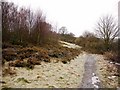
Path east of Dipton
The site of Vane Pit is overgrown on the left. This coal mine was opened in 1740.
Image: © Andrew Curtis
Taken: 7 Jan 2011
0.14 miles
8
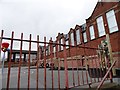
St Patrick's RC Primary School
On North Road, Dipton. There has been a Catholic school here since 1907.
Image: © Robert Graham
Taken: 9 Apr 2014
0.20 miles
10
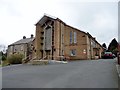
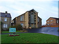
St Patrick's R C Church, Dipton
There has been a church here since 1929. This is the second one, built after the first burnt down in the late C20. The priest's house on the left survived the fire.
Image: © Robert Graham
Taken: 9 Apr 2014
0.21 miles