IMAGES TAKEN NEAR TO
The Avenue, STANLEY, DH9 9AU
Introduction
This page details the photographs taken nearby to The Avenue, DH9 9AU by members of the Geograph project.
The Geograph project started in 2005 with the aim of publishing, organising and preserving representative images for every square kilometre of Great Britain, Ireland and the Isle of Man.

There are currently over 7.5m images from over14,400 individuals and you can help contribute to the project by visiting https://www.geograph.org.uk
Image Map
Images are licensed for reuse under creativecommons.org/licenses/by-sa/2.0
Notes
- Clicking on the map will re-center to the selected point.
- The higher the marker number, the further away the image location is from the centre of the postcode.
Image Listing (34 Images Found)
Images are licensed for reuse under creativecommons.org/licenses/by-sa/2.0
Image
Details
Distance
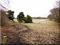
1
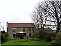
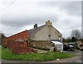
Fondly Set farmhouse
This farm on the southern side of Dipton village was one of those established after the enclosure of Lanchester Common in 1773. This is probably the original farmhouse, although modernised of course.
Image: © Robert Graham
Taken: 9 Apr 2014
0.01 miles
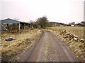
2
Rear view of Fondley Set farmhouse
This farm is on the road out of Dipton village towards Harelaw. The road was originally called Fondleyset Lane but is now usually known as The Avenue, from the row of mighty Beech trees which lines it.
Image: © Robert Graham
Taken: 9 Apr 2014
0.01 miles
3
Fondly Set farmhouse
On the lane of that name in Dipton. The road is however more commonly known as The Avenue, because of the line of Beech trees down it.
Image: © Robert Graham
Taken: 30 Nov 2016
0.02 miles
4
Fondly Set Farm, Dipton
Bridleway in the foreground.
Image: © Oliver Dixon
Taken: 11 Jul 2022
0.03 miles
5
Site of the Stob Pit near Fondleyset Lane
This was a coal mine opened in the 1740s. Several mines were dug in the area in this period connected by a series of wooden-railed waggonways.
Image: © Andrew Curtis
Taken: 7 Jan 2011
0.05 miles
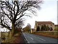
7
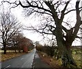
Trees along the Avenue
This road at Dipton is named for the Beech trees which line it on both sides. Pictured in late autumn.
Image: © Robert Graham
Taken: 30 Nov 2016
0.09 miles
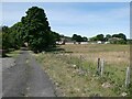
8
Junction of bridleways and footpaths at Stob House
The main track running left to right after the gate is the old Stob Waggonway that was part of an extensive system of wooden railed waggonways in the area which served the many coal pits.
Image: © Andrew Curtis
Taken: 7 Jan 2011
0.10 miles
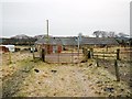
9
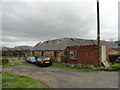
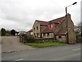
Old outbuildings at Stob House farm, Dipton
A mixture of styles and ages here. The farm itself dates back to the C18.
Image: © Robert Graham
Taken: 9 Apr 2014
0.10 miles
10
Stob House farm, Dipton
Old outbuildings and the gable end of the main range. This farm predates the 1773 Lanchester Common Enclosure Act. It was one of the few farms on the common prior to the enclosure.
Image: © Robert Graham
Taken: 9 Apr 2014
0.11 miles