IMAGES TAKEN NEAR TO
Pontop Pike, STANLEY, DH9 9AS
Introduction
This page details the photographs taken nearby to Pontop Pike, DH9 9AS by members of the Geograph project.
The Geograph project started in 2005 with the aim of publishing, organising and preserving representative images for every square kilometre of Great Britain, Ireland and the Isle of Man.

There are currently over 7.5m images from over14,400 individuals and you can help contribute to the project by visiting https://www.geograph.org.uk
Image Map
Images are licensed for reuse under creativecommons.org/licenses/by-sa/2.0
Notes
- Clicking on the map will re-center to the selected point.
- The higher the marker number, the further away the image location is from the centre of the postcode.
Image Listing (39 Images Found)
Images are licensed for reuse under creativecommons.org/licenses/by-sa/2.0
Image
Details
Distance
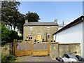
1
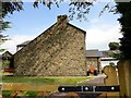
Gable view of the farmhouse at Pontop
This is Pontop Pike Farm, south of Dipton village and at 312m (over 1000 ft), the highest farm in the area. The gable view shows a common feature of these old early 19th century farmhouse, that is, the fact that they commonly have a single storey extension to the rear, with the roof sloped down over this. A catslide roof is the term for this feature.
Image: © Robert Graham
Taken: 26 Aug 2019
0.00 miles
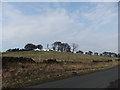
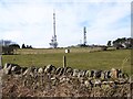
2
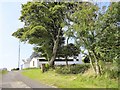
Road leading up to Pontop Pike Farm
View looking west, with the TV mast in the background. The big trees give a bit a much needed shelter for the over 300m elevation (over 1000ft).
Image: © Robert Graham
Taken: 26 Aug 2019
0.00 miles
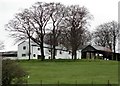
3
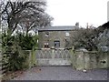
Farmhouse at Pontop Pike Farm
This farm dates back to the late C18 or early C19, after the Lanchester Commons Enclosure Act of 1773 when a lot of the local farms were established on the former common. At nearly 1000ft on top of Pontop Pike it must be a tough place to farm.
Image: © Robert Graham
Taken: 9 Apr 2014
0.00 miles
5
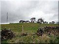
Looking towards Pontop Pike Farm from the Lane
View from Pontop Pike Lane, with the TV mast to the left of the farm buildings.
Image: © Robert Graham
Taken: 9 Apr 2014
0.01 miles
6
Pontop Pike Farm
Front elevation of the farmhouse. A nice example of an early-mid 19th century farmhouse, although it has been altered a bit in recent times.
Image: © Robert Graham
Taken: 26 Aug 2019
0.01 miles
7
Outbuildings at Pontop Pike Farm
The large white painted buildings are probably C19 in origin. They form a prominent feature on top of the Pike.
Image: © Robert Graham
Taken: 9 Apr 2014
0.02 miles
8
Pontop Pike from the lane
View of the T V mast and Pontop Pike Farm from the lane to the east.
Image: © Robert Graham
Taken: 30 Nov 2016
0.05 miles
9
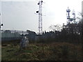
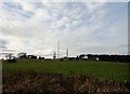
Fields below Pontop Pike
Pontop Pike transmission station Image currently transmits digital television, BBC FM radio and Radio Newcastle over a large part of the North-East. The tallest mast is 149 metres high.
Image: © Oliver Dixon
Taken: 28 Feb 2014
0.07 miles