IMAGES TAKEN NEAR TO
Good Street, STANLEY, DH9 8BE
Introduction
This page details the photographs taken nearby to Good Street, DH9 8BE by members of the Geograph project.
The Geograph project started in 2005 with the aim of publishing, organising and preserving representative images for every square kilometre of Great Britain, Ireland and the Isle of Man.

There are currently over 7.5m images from over14,400 individuals and you can help contribute to the project by visiting https://www.geograph.org.uk
Image Map
Images are licensed for reuse under creativecommons.org/licenses/by-sa/2.0
Notes
- Clicking on the map will re-center to the selected point.
- The higher the marker number, the further away the image location is from the centre of the postcode.
Image Listing (10 Images Found)
Images are licensed for reuse under creativecommons.org/licenses/by-sa/2.0
Image
Details
Distance
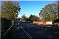
1

Good Street, Stanley
The houses on the left side of the street overlook a large playing area on the right side of the road.
Image: © Graham Robson
Taken: 28 Oct 2018
0.04 miles
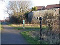
2
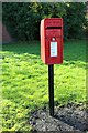
Postbox, Good Street, Stanley
A small postbox on Good Street in a residential part of Stanley.
Image: © Graham Robson
Taken: 28 Oct 2018
0.04 miles
3
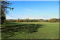
Good Street Sports Fields, Stanley
A large open space for recreation. A football goal is visible at the far end of the space.
Image: © Graham Robson
Taken: 28 Oct 2018
0.05 miles
4
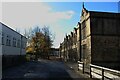
Tanfield School, Stanley
An old stone school building on the right, a slightly more modern rendered building on the left.
Image: © Graham Robson
Taken: 28 Oct 2018
0.10 miles
5
Consett and Sunderland Railway Path at Stanley
Part of National Cycle Network route 7, and the famous C2C Cycle Route. Here crossing the road to Tantobie, B6173
Image: © Oliver Dixon
Taken: 8 Jan 2014
0.14 miles
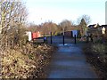
6
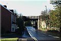
Former railway bridge, Sunny Terrace, Stanley
The bridge crossing Sunny Terrace once carried a railway, it is now trackless and utilised by a route of the National Cycle Network.
Image: © Graham Robson
Taken: 28 Oct 2018
0.15 miles
7
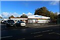
Tony's Tyres, Stanley
An alliteratively named garage providing a car maintenance service on the edge of Stanley.
Image: © Graham Robson
Taken: 28 Oct 2018
0.17 miles
8
Tanfield Lea Road
Tanfield Lea Road's crossing over Houghall Burn can be identified by the brick abutments on either side of the road.
Image: © Graham Robson
Taken: 28 Oct 2018
0.19 miles
9
Consett and Sunderland Railway Path at Stanley
Part of National Cycle Network route 7, and the famous C2C Cycle Route. The milepost is one of 1,000 donated to the NCN project by the Royal Bank of Scotland; this particular one is of the "Welsh" design by Andrew Rowe. The houses to the right are on Charnwood.
Image: © Oliver Dixon
Taken: 8 Jan 2014
0.22 miles
10
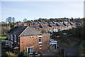
Houses along B6173
The terrace of houses beyond those in the foreground and probably including them, are along the B6173, Osborne Villas, on the outskirts of Stanley in County Durham. They're seen from the Consett & Sunderland Railway Path.
Image: © Trevor Littlewood
Taken: 25 Nov 2021
0.23 miles