IMAGES TAKEN NEAR TO
Thomas Street, STANLEY, DH9 7SN
Introduction
This page details the photographs taken nearby to Thomas Street, DH9 7SN by members of the Geograph project.
The Geograph project started in 2005 with the aim of publishing, organising and preserving representative images for every square kilometre of Great Britain, Ireland and the Isle of Man.

There are currently over 7.5m images from over14,400 individuals and you can help contribute to the project by visiting https://www.geograph.org.uk
Image Map
Images are licensed for reuse under creativecommons.org/licenses/by-sa/2.0
Notes
- Clicking on the map will re-center to the selected point.
- The higher the marker number, the further away the image location is from the centre of the postcode.
Image Listing (32 Images Found)
Images are licensed for reuse under creativecommons.org/licenses/by-sa/2.0
Image
Details
Distance
2
C2C at Annfield Plain
Land on the trackbed of the former Consett and Sunderland railway at Annfield Plain was sold off for housing, but a narrow pathway was retained alongside to carry the C2C (National Cycle Network route 7).
Image: © Oliver Dixon
Taken: 11 Jul 2022
0.09 miles
3
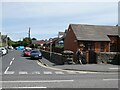
Crossing point on the C2C
Refuge in the centre of Durham Road (B6168), Annfield Plain to provide a safe crossing for the C2C cycle route which follows the line of the former Consett and Sunderland Railway. Annfield Plain Junior School on the far side.
Image: © Oliver Dixon
Taken: 11 Jul 2022
0.09 miles
4
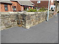
Station Road Bridge abutment
The large, well dressed stones and angles in this front garden wall are the only indications that this is all that remains of the north east abutment of Station Road Bridge, which carried the Birtley, Annfield Plain and Consett railway over the northwest end of Durham Road adjacent to the junction with Station Road and Spring Close.
The former railway is now only used by walkers, cyclists and horse riders exercising on the Consett and Sunderland Railway Path.
There is an Ordnance Survey cut benchmark on one of the large stone quoins on the face of the wall (detail photograph Image).
Image: © Adrian Taylor
Taken: 10 Aug 2020
0.10 miles
5
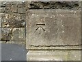
Benchmark, Station Road Bridge
Detail of the Ordnance Survey cut benchmark on the northeast buttress of Station Road Bridge in Annfield Plain. The benchmark marks a height of 235.6683m above mean sea level (Ordnance Datum Newlyn), last verified in 1962 (location photograph Image).
Image: © Adrian Taylor
Taken: 10 Aug 2020
0.10 miles
7
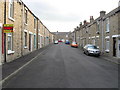
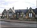
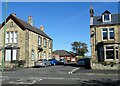
Durham Road, Anfield Plain
Street of big Edwardian terraced houses on the east side of Annfield Plain.
Image: © Robert Graham
Taken: 18 Jul 2012
0.11 miles
8
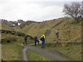
"The ravines" at New Kyo
"The ravines" are a series of artistic earthworks which form an interesting obstacle on the Consett and Sunderland railway path (part of the C2C Cycle Route)
Image: © Oliver Dixon
Taken: 18 Feb 2005
0.11 miles
9
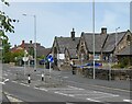
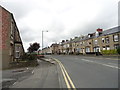
Houses on Durham Road
Long terraced row on the east side of the main village street in Annfield Plain. From old map evidence, the houses here seem to have been built piecemeal from late Victorian to Edwardian times. They do vary quite a lot in style.
Image: © Robert Graham
Taken: 29 Sep 2020
0.11 miles
10
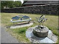
Bench and artwork beside the Consett and Sunderland path
On the C2C cycle route (National Cycle Network route 7) at Annfield Plain.
Image: © Oliver Dixon
Taken: 11 Jul 2022
0.12 miles