IMAGES TAKEN NEAR TO
Carmel Road, STANLEY, DH9 7RJ
Introduction
This page details the photographs taken nearby to Carmel Road, DH9 7RJ by members of the Geograph project.
The Geograph project started in 2005 with the aim of publishing, organising and preserving representative images for every square kilometre of Great Britain, Ireland and the Isle of Man.

There are currently over 7.5m images from over14,400 individuals and you can help contribute to the project by visiting https://www.geograph.org.uk
Image Map
Images are licensed for reuse under creativecommons.org/licenses/by-sa/2.0
Notes
- Clicking on the map will re-center to the selected point.
- The higher the marker number, the further away the image location is from the centre of the postcode.
Image Listing (20 Images Found)
Images are licensed for reuse under creativecommons.org/licenses/by-sa/2.0
Image
Details
Distance
1
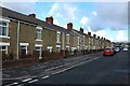
Louisa Terrace, Stanley
A long row of terraced houses close to Stanley town centre.
Image: © Graham Robson
Taken: 28 Oct 2018
0.11 miles
2

A693 entering Stanley
The A693 bypasses the town of Stanley and is seen here approaching from the west. The blue and yellow road sign is in a style in use in County Durham for some years.
Image: © Trevor Littlewood
Taken: 10 Apr 2014
0.11 miles
3
South Moor turn at Oxhill
From the A693 heading for Annfield Plain.
Image: © Pauline E
Taken: 18 Dec 2009
0.13 miles
4
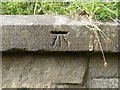
Benchmark, Pea Road Railway Bridge
Detail of the cut benchmark on the south face of the south west wing wall of Pea Road Railway Bridge (location photograph Image).
This benchmark does not appear to be shown on old OS maps and it is not listed on the Ordnance Survey Benchmark Database.
The benchmark has an unusually deep datum line.
Image: © Adrian Taylor
Taken: 10 Aug 2020
0.14 miles
5

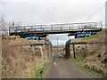
Pea Road Railway Bridge
Detail of the north east abutment of Pea Road Railway Bridge.
The bridge was rebuilt when the Consett and Sunderland Railway Path was created. The metal bridge deck is supported upon the two ends of a former British Rail container flat wagon complete with bogies and wheels, set on short lengths of bullhead rail track with concrete sleepers.
Image: © Adrian Taylor
Taken: 10 Aug 2020
0.14 miles
6
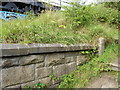
Wing wall, Pea Road Railway Bridge
Detail of the stone built wing wall of Pea Road Railway Bridge. In front of the wall is a path leading up onto the Consett and Sunderland Railway Path.
The metal bridge deck is supported upon two halves of a British Rail container flat wagon complete with bogies and wheels, part of which can be seen.
There is a cut benchmark symbol on the coping stone of the wall (photograph Image).
Image: © Adrian Taylor
Taken: 10 Aug 2020
0.14 miles
7
Bridge on the Railway Path at Oxhill
This must be the most unusual bridge on the Consett & Sunderland Railway Path. Consisting of an old railway freight car, it was installed about 20 years ago by engineers from the Territorial Army. Some years later, the upper part of the car was removed, leaving just the flatbed, and handrails added.
Image: © Robert Graham
Taken: 9 Mar 2012
0.14 miles
8
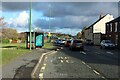
The A693, Oxhill, Stanley
A busy road for traffic coming and going to and from Stanley town centre. A layby has been provided for buses dropping off and pickup passengers at the bus stop.
Image: © Graham Robson
Taken: 28 Oct 2018
0.15 miles
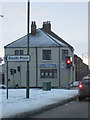
9
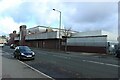
Supermarket and bowls centre, Stanley
An ASDA supermarket occupies the ground floor of this large building, and an indoor bowls centre occupies the upper floor.
Image: © Graham Robson
Taken: 28 Oct 2018
0.18 miles
10
Asda
View of one of the large prominent buildings when travelling through Stanley.
Image: © Colin Edgar
Taken: 15 Jan 2006
0.19 miles