IMAGES TAKEN NEAR TO
Front Street, STANLEY, DH9 7EY
Introduction
This page details the photographs taken nearby to Front Street, DH9 7EY by members of the Geograph project.
The Geograph project started in 2005 with the aim of publishing, organising and preserving representative images for every square kilometre of Great Britain, Ireland and the Isle of Man.

There are currently over 7.5m images from over14,400 individuals and you can help contribute to the project by visiting https://www.geograph.org.uk
Image Map
Images are licensed for reuse under creativecommons.org/licenses/by-sa/2.0
Notes
- Clicking on the map will re-center to the selected point.
- The higher the marker number, the further away the image location is from the centre of the postcode.
Image Listing (16 Images Found)
Images are licensed for reuse under creativecommons.org/licenses/by-sa/2.0
Image
Details
Distance
1
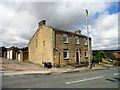
The White House, Quaking Houses
This building standing at the top of the bank at Quaking Houses, was once a public house.
Image: © Robert Graham
Taken: 18 Jul 2012
0.02 miles
2
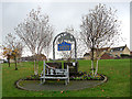
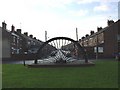
Village sign for Quaking Houses
This green corridor at the eastern end of the former mining village of Quaking Houses is on the site of the old coal mine. The old pit wheel can be seen in the background. The name possibly derives from being originally settled by Quakers, prior to the development of the mine.
Image: © Oliver Dixon
Taken: 31 Oct 2014
0.03 miles
3
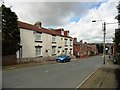
Former Stag Inn
This is the second of the pubs on Park Road at Quaking Houses. They are both now private houses, there is no pub in the village currently.
Image: © Robert Graham
Taken: 18 Jul 2012
0.04 miles
4
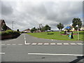
Road leading into Quaking Houses
This is a little ex mining community near Stanley. The open space here at the east end of the village is the site of the former colliery.
Image: © Robert Graham
Taken: 18 Jul 2012
0.06 miles
5
Quaking Houses
Entrance to Quaking Houses, taken from the site of the old pit.
Image: © Bluespacecat
Taken: 26 Nov 2005
0.11 miles
6
Wilgrow Nursery, Newacres Road
For more information, see http://www.wilgrownursery.co.uk/ .
Image: © Christine Johnstone
Taken: 14 Apr 2012
0.12 miles
7
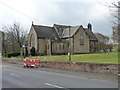
St George's Church, South Moor Road
Built in 1897.
Image: © Christine Johnstone
Taken: 14 Apr 2012
0.13 miles
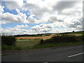
8
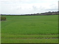
Cereal field, west of South Moor golf course
And east of Newacres Road.
Image: © Christine Johnstone
Taken: 14 Apr 2012
0.14 miles
9
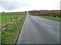
Newacres Road
Heading up the hill to New Acres.
Image: © Christine Johnstone
Taken: 14 Apr 2012
0.16 miles
10
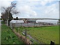
View east from the bottom of Newacres Road
Looking over the fields towards the wind turbines on Wagtail Lane, which runs along the ridge top.
Image: © Robert Graham
Taken: 18 Jul 2012
0.16 miles